The impact of large floods on fluvial systems in northern Yellowstone National Park
Overview: This six-student Gateway project will introduce five rising sophomores to field-based applied fluvial geomorphology research and provide a senior thesis for a rising senior peer mentor. The project will be based out of Walla Walla and include a 2.5-week field excursion to northern Yellowstone National Park. As part of this project, we will meet with park employees, environmental consultants, and Whitman college seniors working on thesis research. In June of 2022 an historic rain-on-snow event produced widespread flooding and erosion in the northern portion of the Greater Yellowstone Ecosystem (GYE). Large rain-on-snow floods have created large and persistent channel changes in Yellowstone in the past, and they may become more common in a warming climate. Additionally, the role of vegetation versus physical controls (e.g. sediment supply and major floods) as the primary drivers of fluvial morphodynamics is unclear for tributaries of the Yellowstone River (Figure 1) and elsewhere in mountain landscapes. The extreme June 2022 event provides a rare opportunity to examine its magnitude and effects on Yellowstone River tributaries. The research experience is designed to have students participate in a broad array of field-based methods to introduce field research in the Earth Sciences. The data collection will build on recent data sets collected by Persico for his 2019 Keck project and 2022 NSF-RAPID award. Students will participate in RTK GPS surveys of river channels, identification of flood stage indicators (high water marks), discharge estimates using an acoustic doppler velocimeter, channel bed characterization via pebble counts, geomorphic mapping, and radiocarbon sampling. The research project will culminate in a group poster presentation at the 2024 joint sectional (Rocky Mountain and Cordilleran) meeting of the Geological Society of America in Spokane, WA.
When: July 17 – August 18, 2023
Where: Whitman College, Walla Walla, Washington
Who: Five rising sophomores, one peer mentor (senior), and project director Lyman Persico, Whitman College, persiclp@whitman.edu
Expectations and Obligations:
We seek motivated, driven students that are comfortable working independently and that can work and collaborate well with others. You will be expected to take ownership of your project with guidance from the advisors. This entails collecting, organizing, analyzing, interpreting and presenting data in written and oral form. Students on this project are obligated to:
- Participate in all project-related work during the summer (July 17 – August 18, 2023)
2. Write a team abstract and present a paper (poster or talk) at the Geological Society of America Meeting in Spokane, Washington, May 15-17, 2024 (all expenses covered)

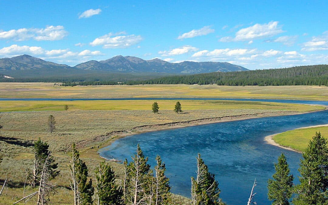
Figure 1. Rivers in northern Yellowstone were most impacted by the June 2022 flood. Red boxes indicate proposed study reaches. Green dotted line is the extent of the Northern Range where the relative importance of biotic and abiotic controls on fluvial morphodynamics has been studied.

Figure 2. Characteristics of the snowpack on June 13, 2022, prior to the rain on snow event. A. The snow water equivalent was in excess of 1 meter throughout much of the high elevation terrain in the Gallatin, Beartooth, and Washburn Ranges. B. The warm snowpack was just below freezing temperatures.
PROJECT DESCRIPTION
From June 10–13, 2022 an atmospheric river delivered 2.5–10 cm of rain in and around northern Yellowstone National Park. The rain melted 5–13 cm of warm snow water equivalent resulting (Figure 2) in a total of 7.6–23 cm of water delivered to the landscape (National Weather Service, 2022). Peak discharges on at least four stream gages on the Yellowstone River and its tributaries exceeded the flood of record, and at two of the gages (Corwin Springs and Livingston), the U.S. Geological Survey indicated that the peak flow exceeded the 0.2% (1 in 500) flood. Flooding caused significant impacts to park infrastructure including roads and campgrounds (Figure 3). Extreme rain-on-snow floods have created large and persistent channel changes in Yellowstone in the past (Meyer, 2001). Due to climate change, they are likely to be more common in the greater Yellowstone ecosystem (Whitlock et al., 2017) and throughout much of western North America (Musselman et al., 2018; Payne et al., 2020). Considerable uncertainty exists, however, in terms of how climate change will alter temporal patterns and intensity of precipitation, how such changes will alter hillslope processes (e.g., landslides and other erosion) and flooding, and how river systems will respond (East and Sankey, 2020).
Yellowstone is iconic not only because of its wildlife, hydrothermal features, and as America’s oldest national park, but also as a field laboratory for investigating key questions in surface processes, including about the influences of biotic-abiotic feedbacks and of extreme events on landscape form and processes. Riparian corridors are key ecological zones in semiarid regions, as they provide abundant water and food resources and are typically more biologically diverse than the overall landscape. These corridors are particularly important in the relatively dry Northern Range of Yellowstone National Park (Yellowstone National Park, 1997). The Northern Range is synonymous with the winter range of the northern Yellowstone Elk herd. The Northern Range (Fig. 1) is relatively dry (mean annual precipitation: 350-500 mm) and the low-elevation region is dominated by sagebrush-grasslands with scattered conifer groves. In the early 20th century, many streams in the Northern Range hosted abundant beaver and beaver dams (Warren, 1926). Beaver are considered a keystone species of riverine-riparian ecosystems (Naiman et al., 1988b) as beaver dams elevate water tables, expand riparian habitat, increase aquatic productivity, and store more groundwater (Anderson et al., 2006; Brzyski and Schulte, 2009; Cooke and Zack, 2008; Green and Westbrook, 2009; Gribb, 2007; Gurnell, 1998; Naiman et al., 1988a; Naiman et al., 1986; Pollock et al., 1995; Westbrook et al., 2006). Beaver dams also reduce stream velocity and induce sedimentation in channels and on floodplains (Butler and Malanson, 1995). It has been hypothesized that the long-term effect of beaver damming may substantially aggrade valley floors (Ives, 1942; Ruedemann and Schoonmaker, 1938). More recent research using 14C dating, however, has shown that there are limits on the net aggradation of beaver damming to less than 3 meters (Persico and Meyer, 2009, 2012; Polvi and Wohl, 2012).
Interestingly, beaver have been largely absent from the Northern Range since the mid-20th century (Fig. 4, Jonas, 1955). The causes of beaver decline and associated riparian zone changes have been debated in both the scientific literature and popular press over the past three decades (National Research Council, 2002; Yellowstone National Park, 1997). It has been proposed that Northern Range streams experienced an ecosystem state switch from beaver-willow to elk-grasslands during the latter half of the 20th century (Wolf et al., 2007). According to some, the loss of beaver is the direct result of competition from elk (Chadde and Kay, 1991). Elk populations increased dramatically in the 20th century due to the extirpation of wolves by hunting. Large elk populations have led to over-browsing of willow and other riparian vegetation. Mature aspen and riparian tall-willow stands, important food resources for beaver, have declined since park establishment, but aspen were never abundant in historic or Holocene time (Houston, 1982; Romme et al., 1995; Whitlock and Bartlein, 1993).

Figure 3. Flooding at the Confluence of Pebble and Soda Butte Creeks on June 13, 2022. The flood washed out highway US 212 in multiple locations upstream and downstream of the confluence. Photo courtesy of the National Park Service.

Figure 4. The Northern Range stream of Elk Creek contained many beaver dams in the 1920s that extended across much of the valley floor. Those beaver dams were abandoned by the 1920s and the stream has incised over 2 m from the top of the beaver bond sediments.
The trophic cascade hypothesis posits that riparian vegetation is the dominant control on modern channel form in Yellowstone, as the result of a sequence whereby elimination of wolves in the first half of the 20th century led to increases in the elk population and thus overbrowsing of riparian willows (Beschta and Ripple, 2006; Beschta and Ripple, 2018). According to this view, these trophic-cascade changes triggered abiotic changes in the mid-20th century by altering bank stability and channel morphology, and by reducing overbank flood frequency via incision (Figure 4, Beschta and Ripple, 2006; Beschta and Ripple, 2018).
An alternative interpretation is that physical controls such as sediment supply and major floods may be the primary drivers of channel form in such environments (East et al., 2017). More generally, investigation of how life influences landscapes (Dietrich and Perron, 2006) has been a key avenue of earth-systems research in the last two decades, including for example the influence of beaver (Persico and Meyer, 2009, 2012) and feedbacks between riparian vegetation and fluvial morphodynamics (e.g. Bywater-Reyes et al., 2022; Manners et al., 2015). Understanding landscape response to climate change, including to the integrated effects of changes in wildfire regimes, droughts and floods, and altered sediment supply, as well as the related question of how earth science can reduce geohazards risks, also represent vital research (National Academies of Sciences and Medicine, 2020). The extreme June 2022 event in Yellowstone provides a rare opportunity to combine these research foci, via examination of its magnitude and effects on Yellowstone River tributaries, assessment of whether its impacts exceed those of past floods, consideration of the relative importance of vegetation-related versus physical controls on channel morphology and flood impacts (Figure 5).

Figure 5. On the east fork of Blacktail Deer Creek incision has been attributed to trophic-cascade related changes to vegetation (Beschta and Ripple, 2018). However, sediments in a terrace ~1.5 above the modern floodplain accumulated 7-3 ka and incision commenced ~1.5 ka (Persico and Meyer, 2009). It is unknown how widespread this surface is or its relationship to the historical floodplain proposed by Bescthta and Ripple (2018).

Figure 6. The impacts of flooding were not consistent across northern Yellowstone. A. Flooding on the Gardner River caused significant erosion to floodplain and alluvial fans. B. On the Gallatin River, the river channel modification was minimal and the effects of the flood were subdued despite draining the same range as the Gardner River.
Research questions
The proposed research will contribute to our ongoing investigations of the following questions:
1. How do the magnitude and geomorphic effects of the June 2022 event compare to major floods of the last few hundred years in northern Yellowstone (Meyer, 2001), and are differences indicative of climate change effects?
2. How did the June 2022 affect channel and floodplain morphology and sediment character, and how do variations in aggradation, incision, and channel geometry change relate to reach-scale physical controls including stream power, channel confinement, and bed-material caliber (Figure 6)?
3. How do flood effects differ between reaches with different vegetation conditions and histories? What is the relative importance of large floods versus vegetation density and composition in controlling channel form?
4. How did fluvial system response vary spatially across different ranges with different basin morphologies and what can we learn from such responses about landscape sensitivity or resilience to climate-change-induced extreme events (Figure 7)?
Proposed Research
Research goals include continued estimation of the hydraulics of the June 2022 flood on various streams in the northern GYE. Methods include (1) RTK surveys of channel cross sections, (2) geomorphic and vegetation mapping and sediment characterization of floodplains and channels, including use of aerial imagery for historic conditions, (3) surveying of stage indicators for HEC-RAS discharge reconstructions, and (4) discharge measurements using acoustic doppler velocimeter. HEC-RAS modeling will be used to investigate hydraulics of the current flood and altered floodplain inundation levels. The 2023 field campaign will focus on rivers not surveyed in the summer of 2022. In particular, we will focus on river in northeast Yellowstone National Park that were not accessible in 2023. Discharge estimates will be performed on confined reaches where there are clear stage indicators on Tower Creek, Pebble Creek, Soda Butte Creek, Buffalo Creek, and Rose Creek. In addition to discharge reconstructions, we will document how the flood affected channel geometry and floodplain character, including incision and/or aggradation in light of prior channel and vegetation conditions and basin morphometry. Channel surveys by Meyer (2001) to reconstruct 1918 extreme flood discharges on Soda Butte and Pebble Creeks provide for comparison with 2022 flood peaks and measurement of subsequent channel change. In 2019, and 2021, channels on Blacktail Deer Creek were GPS surveyed to cm-scale accuracy and bed material size was measured, providing a recent baseline (Persico, 2020). These channels were resurveyed in 2022. In 2023 we will measure real time discharge on Blacktail Deer Creek and other streams surveyed in 2022 to help constrain Manning’s n estimates, a necessary parameter for discharge reconstructions.
Learning outcomes
Students in this research project begin or continue to hone their skills in:
- Planning field research expeditions
- Using field research equipment including RTK GPS, acoustic doppler velocimeter, gravelometer
- Geomorphic mapping
- Camping
- Using ArcGIS, Excel, and HecRas to analyze geomorphic and hydrologic data sets
- Formulate a science story that integrates their research into a broader intellectual framework for understanding geomorphic systems
- Communicate results of the research using oral, visual, and written forms.

Figure 7. Maximum recorded and 100-year peak discharge estimates for gauged rivers in the upper Yellowstone drainage basing from Meyer (2001). Filled red squares are peak discharges from the 2022 flood on rivers draining the Washburn and Gallatin Ranges. Open red squares are from peak discharges on rivers draining the Beartooth Range. The peak discharges are significantly higher on rivers draining the Beartooth Range despite a heavy snowpack and similar rain amounts throughout the region. The higher peak discharges may be related to geomorphic factors in the different drainage basins as the Beartooths are steeper with more exposed bedrock.
PROJECT LOGISTICS
Students will arrive in Walla Walla and stay on campus at Whitman College for the first 1.5 weeks. While on campus students will participate in combination of lectures and activities. Specific topics that will be covered will include fluvial geomorphology, history of Yellowstone, how (and why) to formulate research questions, and how to plan scientific research. Additionally, the students will begin learning how to use field equipment including the RTK GPS and acoustic doppler velocimeter. The goal is to have the students proficient in using field equipment before adding the additional complication of camping. During this time, students will participate in lecture/demonstrations on the basics of camping including tents, food preparation, and camp maintenance. During this time there will be four rising seniors that will be finishing up their summer research at Whitman. The Keck students will have the opportunity to learn about research and being a science major from the thesis students including a field trip (if possible) to thesis research locations in the Columbia River Valley.
While in Yellowstone we will first stay north of the park, near Gardiner, MT. We will likely camp at the Eagle Creek campground, although, the campground is first-come-first-serve, so the backup plan is to stay at the Jardine campground, which is more remote and not as likely to fill up. Most meals will be prepared at the campsite on camp stoves borrowed from the Whitman College. We will resupply, shower, and do laundry in the town of Gardiner. While in Yellowstone, the students will have the opportunity to interact with several NPS and USFS staff for professional development opportunities. We will meet with the park archeologists to learn about identifying indigenous artifacts during field and the importance of minimizing impacts to park resources. Will also meet with park research coordinator and a ranger to learn more about their jobs as well.
Students will need to be able to carry a medium-sized field pack and field equipment every day. We will also pack water and lunch each day. We will be hiking up to six miles per day. Most of the hiking will be on the valley floor, thus relatively low gradients. We will also be surveying stream cross sections. This will require multiple river crossings. We will use chest waders and hiking poles provided by Whitman College. The Northern Range of Yellowstone is occupied by black bears during the summer months. Project Director Persico has 10+ seasons of field experience with Yellowstone bears and rivers. He will train the students on proper stream crossings and bear management including the use of bear deterrents. Each member of the team will have a can of bear spray.
On August 12th we will drive back to Walla Walla and spend the remainder of the time (~1 week) together at Whitman College. Students will focus on analyzing field data and learning post-field research activities. 14C samples will be cleaned of modern organics and sent to a dating laboratory. The field survey data will be processed using Topcon’s GPS software and analyzed using ArcGIS. As we are processing data, we will begin to construct a “science story” of the research they will present at GSA. The science story will be focused on the research they collected this summer and they will contextualize the results with data collected in the summer of 2022. The students will write an abstract and create a poster of their research for the GSA meeting. Students will leave Whitman College with a clear plan for any remaining work that must be completed for the poster. During the semester I will help students prepare for the presentation at GSA.
PROFESSIONAL DEVELOPMENT
We will present our research at the Geological Society of America meeting in Spokane, WA (15-17 May 2024). The peer mentor will write their own abstract and include the students and coauthors. The rest of the students will prepare their own poster with guidance from me and the peer mentor. We will also participate in GSA activities that are focused on students and career preparation/planning.
References
Anderson, C. B., Griffith, C. R., Rosemond, A. D., Rozzi, R., and Dollenz, O., 2006, The effects of invasive North American beavers on riparian plant communities in Cape Horn, Chile – Do exotic beavers engineer differently in sub-Antarctic ecosystems?: Biological Conservation, v. 128, no. 4, p. 467-474.
Beschta, R. L., and Ripple, W. J., 2006, River channel dynamics following extirpation of wolves in northwestern Yellowstone National Park, USA: Earth Surface Processes and Landforms, v. 31, no. 12, p. 1525-1539.
Beschta, R. L., and Ripple, W. J., 2018, Can large carnivores change streams via a trophic cascade?: Ecohydrology, v. 0, no. 0, p. e2048.
Brzyski, J. R., and Schulte, B. A., 2009, Beaver (Castor canadensis) Impacts on Herbaceous and Woody Vegetation in Southeastern Georgia: American Midland Naturalist, v. 162, no. 1, p. 74-86.
Butler, D. R., and Malanson, G. P., 1995, Sedimentation rates and patterns in beaver ponds in a mountain environment: Geomorphology, v. 13, no. 1-4, p. 255-269.
Bywater-Reyes, S., Diehl, R. M., Wilcox, A. C., Stella, J. C., and Kui, L., 2022, A Green New Balance: Interactions among riparian vegetation plant traits and morphodynamics in alluvial rivers: Earth Surface Processes and Landforms, v. 47, no. 10, p. 2410-2436.
Chadde, S. W., and Kay, C. E., 1991, Tall-willow communities on Yellowstone’s Northern Range: A test of the “natural-regulation” paradigm, in Keiter, R. B., and Boyce, M. S., eds., The Greater Yellowstone Ecosystem: Binghamton, Yale University Press, p. 231-263.
Cooke, H. A., and Zack, S., 2008, Influence of beaver dam density on riparian areas and riparian birds in shrubsteppe of Wyoming: Western North American Naturalist, v. 68, no. 3, p. 365-373.
Dietrich, W. E., and Perron, J. T., 2006, The search for a topographic signature of life: Nature, v. 439, no. 7075, p. 411-418.
East, A. E., Jenkins, K. J., Happe, P. J., Bountry, J. A., Beechie, T. J., Mastin, M. C., Sankey, J. B., and Randle, T. J., 2017, Channel-planform evolution in four rivers of Olympic National Park, Washington, USA: the roles of physical drivers and trophic cascades: Earth Surface Processes and Landforms, v. 42, no. 7, p. 1011-1032.
East, A. E., and Sankey, J. B., 2020, Geomorphic and Sedimentary Effects of Modern Climate Change: Current and Anticipated Future Conditions in the Western United States: Reviews of Geophysics, v. 58, no. 4, p. e2019RG000692.
Green, K. C., and Westbrook, C. J., 2009, Changes in riparian area structure, channel hydraulics, and sediment yield following loss of beaver dams: Journal of Ecosystems and Management, v. 10, no. 1, p. 68-79.
Gribb, W., 2007, Beaver (Castor canadensis) impacts and characteristics on stream hydrology and vegetation in the Snake River Drainage System, Grand Teton National Park, Wyoming: United States Department of the Interior, Investigator’s annual report, GRTE-00055.
Gurnell, A., 1998, The hydrogeomorphological effects of beaver dam-building activity: Progress in Physical Geography, v. 22, no. 2, p. 167-189.
Houston, D. B., 1982, The northern Yellowstone elk, New York, NY, Macmillian.
Ives, R., 1942, The beaver-meadow complex: Journal of Geomorphology, v. 5, no. 3, p. 191-203.
Jonas, R. J., 1955, A population and ecological study of the beaver (Castor canadensis) of Yellowstone National ParkM.S.]: University of Idaho, 193 p.
Manners, R. B., Wilcox, A. C., Kui, L., Lightbody, A. F., Stella, J. C., and Sklar, L. S., 2015, When do plants modify fluvial processes? Plant-hydraulic interactions under variable flow and sediment supply rates: Journal of Geophysical Research: Earth Surface, v. 120, no. 2, p. 325-345.
Meyer, G. A., 2001, Recent large-magnitude floods and their impact on valley-floor environments of northeastern Yellowstone: Geomorphology, v. 40, no. 3-4, p. 271-290.
Musselman, K. N., Lehner, F., Ikeda, K., Clark, M. P., Prein, A. F., Liu, C., Barlage, M., and Rasmussen, R., 2018, Projected increases and shifts in rain-on-snow flood risk over western North America: Nature Climate Change, v. 8, no. 9, p. 808-812.
Naiman, R. J., Johnston, C. A., and Kelley, J. C., 1988a, Alteration of North-American streams by beaver: Bioscience, v. 38, no. 11, p. 753-762.
Naiman, R. J., Johnston, C. A., and Kelly, J. C., 1988b, Alteration of North American streams by beaver: Bioscience, v. 38, p. 753-762.
Naiman, R. J., Melillo, J. M., and Hobbie, J. E., 1986, Ecosystem alteration of boreal forest streams by beaver (Castor-canadensis): Ecology, v. 67, no. 5, p. 1254-1269.
National Academies of Sciences, E., and Medicine, 2020, A Vision for NSF Earth Sciences 2020-2030: Earth in Time, Washington, DC, The National Academies Press, 144 p.:
National Research Council, 2002, Ecological Dynamics on Yellowstone’s Northern Range, Washington DC, National Academy Press.
National Weather Service, 2022, June 2022 Unprecedented Flooding in South-Central Montana.
Payne, A. E., Demory, M.-E., Leung, L. R., Ramos, A. M., Shields, C. A., Rutz, J. J., Siler, N., Villarini, G., Hall, A., and Ralph, F. M., 2020, Responses and impacts of atmospheric rivers to climate change: Nature Reviews Earth & Environment, v. 1, no. 3, p. 143-157.
Persico, L., and Meyer, G., 2009, Holocene beaver damming, fluvial geomorphology, and climate in Yellowstone National Park, Wyoming: Quaternary Research, v. 71, no. 3, p. 340-353.
-, 2012, Natural and historical variability in fluvial processes, beaver activity, and climate in the Greater Yellowstone Ecosystem: Earth Surface Processes and Landforms, v. 38, no. 7, p. 728-750.
Persico, L. P., 2020, The Importance of Geomorphic Controls on Hydraulic Processes in Northern Yellowstone National Park: Keck Geology Consortium Short Contributions, v. 30.
Pollock, M. M., Naiman, R. J., Erickson, C. A., Johnston, C. A., Paster, J., and Pinay, G., 1995, Beaver as engineers: influences of biotic and abiotic characteristics of drainage basins, in Jones, C. G., and Lawton, J. H., eds., Linking species and ecosystems: New York, Chapman and Hall, p. 117-126.
Polvi, L. E., and Wohl, E., 2012, The beaver meadow complex revisited – the role of beavers in post-glacial floodplain development: Earth Surface Processes and Landforms, v. 37, no. 3, p. 332-346.
Romme, W. H., Turner, M. G., Wallace, L. L., and Walker, J. S., 1995, Aspen, elk, and fire in northern Yellowstone National Park: Ecology, v. 76, no. 7, p. 2097-2106.
Ruedemann, R., and Schoonmaker, W., 1938, Beaver-dams as geologic agents: Science, v. 88, no. 2292, p. 523-525.
Warren, E. R., 1926, A study of the beaver in the Yancey region of Yellowstone National Park, Syracuse, Roosevelt Wildlife Annals 1.
Westbrook, C. J., Cooper, D. J., and Baker, B. W., 2006, Beaver dams and overbank floods influence groundwater-surface water interactions of a Rocky Mountain riparian area: Water Resources Research, v. 42, no. 6, p. 2005WR004560.
Whitlock, C., and Bartlein, P. J., 1993, Spatial variations of Holocene climatic change in the Yellowstone region: Quaternary Research, v. 39, p. 231-238.