Geochemical controls on uranium contamination of groundwater in the Central Valley and High Plains aquifer systems
Overview: Two of the most agriculturally productive regions in the world are the western Great Plains, which grows the majority of U.S. grain, and the Central Valley of California, which grows the majority of the nation’s fruits, vegetables, and nuts1. In both locales, groundwater is heavily pumped from the underlying High Plains (HP) and Central Valley (CV) aquifers for irrigation and the land surface is fertilized to aid crop growth2,3. A combined estimate of six million people from these regions rely on groundwater as their primary drinking water source4. Human activity has polluted groundwater in both aquifers, altering their chemistry such that groundwater in many areas of the HP and CV aquifers poses a human health hazard and financial burden to municipal water districts. This research will explore natural and human-triggered geochemical processes that mobilize uranium (U) in the HP and CV aquifers in an effort to protect human health and food production.
When: June 11 – July 16, 2023
Where: Trinity University, San Antonio, TX
Who: Four rising sophomores, one peer mentor (junior or senior), and project director Dr. Brady Ziegler (Trinity University)
Expectations and Obligations:
We seek motivated, driven students that are comfortable working independently and that can work and collaborate well with others. You will be expected to take ownership of your project with guidance from the advisors. This entails collecting, organizing, analyzing, interpreting and presenting data in written and oral form. Students on this project are obligated to:
- Participate in all project-related work during the summer (June 11 – July 16, 2023)
2. Write a team abstract and present a paper (poster or talk) at the Geological Society of America National Meeting in Pittsburgh, Pennsylvania, October 15-18, 2023 (all expenses covered)
PROJECT DESCRIPTION
Intensive agricultural activity has raised concerns regarding surface and groundwater quality throughout both aquifer systems. Nitrate (NO3–) is commonly applied to the land surface in HP and CV as fertilizer to increase agricultural yields4. However, the introduction of NO3– can have unforeseen consequences on water quality such as the mobilization of geogenic contaminants, such as uranium5, which commonly exists in the aquifer sediments ranging in concentration from 2 to 4 mg/kg as reduced U(IV) form in the mineral uraninite (UO2)6. In this study, we will conduct a groundwater quality survey using publicly available data and perform laboratory experiments on native sediments from the CV to elucidate geochemical mechanisms that mobilize U into groundwater in the CV and HP aquifers.
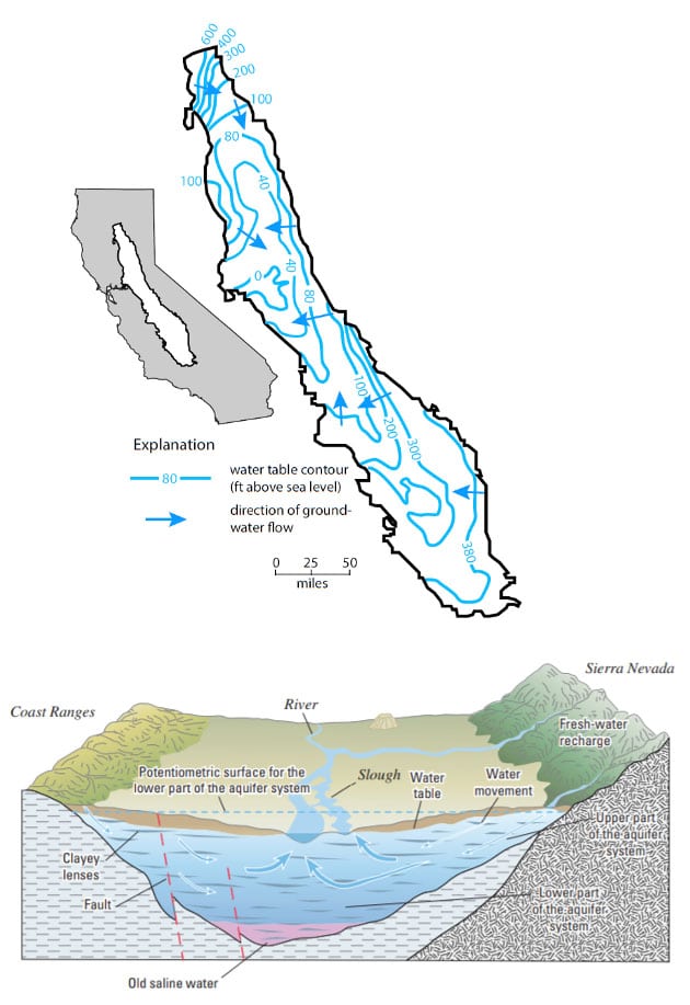
The CV aquifer system (Figure 1) is a valley filled with unconsolidated sediment weathered from the igneous and metamorphic rocks of the Sierra Nevada to the east and the marine Coastal Range to the west, resulting in complex stratigraphy of permeable sands and gravels that are confined or semi-confined by discontinuous silt and clay lenses7-9. In the Middle Pleistocene, Corcoran Lake covered much of the western side of the CV, leaving behind the lacustrine Corcoran Clay, a relatively continuous confining unit that generally separates shallow unconfined groundwater from deeper confined groundwater10. Water recharges the aquifer from the valley margins, and water flows toward the valley center, upwelling and discharging into the San Joaquin River in the south and the Sacramento River in the north, ultimately discharging into the San Francisco Bay. Groundwater pumping in the last century has led to widespread alternation of groundwater flow paths by lowering the potentiometric surface of the deeper confined aquifer in regions of excess pumping11.
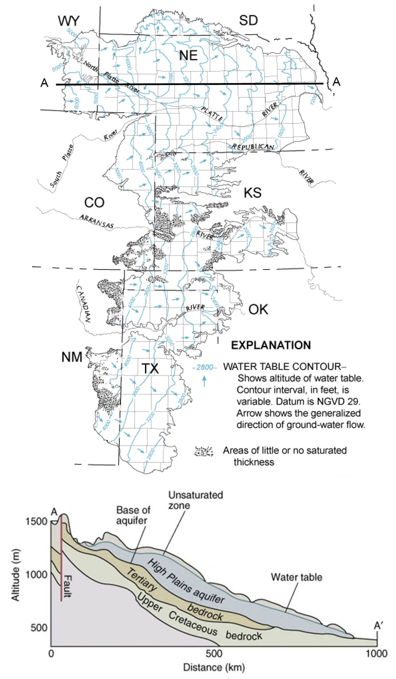
The HP aquifer system (Figure 2) is a collective unit of alluvial deposits of unconsolidated sands, gravels and silts eroded from the igneous and metamorphic Rocky Mountains to the west12. The aquifer system covers much of the central U.S. varying greatly in thickness from >300 m in Nebraska to <15 m in north Texas. Generally, the aquifer is unconfined for its full aquifer thickness and grades from coarse to fine grain sizes from west to east12. Occasional discontinuous fine-grained lenses serve as semi-confining units toward the east. Naturally, groundwater flows west to east, ultimately discharging into the numerous river systems that ultimately discharge into the Gulf of Mexico. Groundwater is heavily pumped from the HP aquifer to support agriculture irrigation, severely disrupted the natural hydraulic gradient. In some areas, the water table has been lowered more than 50 m due to overpumping13.

Figure 1. Water table contour map (top) showing the elevation of the water table and direction of groundwater flow in the Central Valley. The regional flow across the valley is shown in cross section (bottom); modified from Williamson et al., (1989) and DeSimone et al. (2009).

Figure 2. Water table contour map (top) showing the elevation of the water table and direction of groundwater flow in the HP aquifer. Cross section (bottom) is shown from A to A’; modified from Gutentag et al.12.
Overarching research goals and questions
The overarching goal of this project is to better resolve the reaction mechanisms responsible for U mobilization and groundwater contamination in the CV. In addition, we aim to further explore the mechanisms we found responsible for U mobilization in the CV aquifer and evaluate their relevance to U mobilization in the HP aquifer. To achieve these goals, this research project will aim to answer the following research questions:
- To what extent, and how fast, does U leach from CV sediments under various chemical conditions?
- Does elevated U in the HP aquifer co-occur with elevated NO3–, CO32-, or both?
- What is the dominant U species in the HP aquifer where U exceeds the 30 μg/L MCL?
Potential student projects
To address these research questions, we have identified two potential student projects that use a combination of laboratory analyses and computational methods to characterize U dissolution rates from aquifer sediments and geochemical U dissolution mechanisms. Students will work together in pairs, where each pair will take ownership of one of the two projects, though they will participate collaboratively on both projects. Additionally, we will have a former Keck student working in the laboratory who will serve as a peer mentor for the Gateway students.
Project 1: Determination of U leaching from CV sediments under different chemical conditions
Project 2: Spatial and statistical assessment of U geochemistry in the HP aquifer
Learning outcomes
Students participating in this project will learn to:
- Plan and implement a robust experimental design;
- Perform fundamental and specialized laboratory skills, including creating robust quantitative solutions, pipetting, anaerobic work;
- Access, download, and manage big data;
- Perform fundamental and advanced statistical analyses using the R programming language;
- Use ArcGIS to perform spatial analyses of concentration data;
- Perform basic skills in geochemical modeling;
- Compile research results into a well reasoned scientific narrative; and
- Communicate research results to others through oral, visual, and written means.
PROJECT LOGISTICS
Students will fly to San Antonio on the weekend of June 10 and move into on-campus housing in the Trinity University dorms, with two students per room. Starting June 12, one week will be dedicated to training students in laboratory techniques, computational software (R and ArcGIS) and the overall project objectives. After the training period, students will then begin working on the two projects as outlined above. During this research-intensive phase, students will begin processing sediments and preparing solutions for their leaching experiments and possibly analyzing sediment samples on the TU SEM and possibly XRD at the University of Texas San Antonio. The second group will begin accessing and downloading data and performing numerous data management and pre-processing steps prior to statistical and geospatial analyses. During this phase, Mark Nickels, who participated in our 2021 Keck project and has since continued research on U in the CV aquifer as a senior thesis will serve as a peer mentor in the lab and for the computational component.
During the fourth week, students will travel to University of Texas San Antonio to analyze samples from their leaching experiments using inductively coupled plasma mass spectrometry in Dr. Saugata Datta’s lab. The computational group will join in this lab field trip to learn new laboratory skills and broaden their geosciences network. Both groups will spend the remainder of week four intensively analyzing their data.
During the last week, students will collaborate to write and submit multiple abstracts (actual number to be determined based on analytical results) for posters to be presented at the Geological Society of America meeting in Fall 2023. Students will depart San Antonio the weekend of July 16.
PROFESSIONAL DEVELOPMENT
In the last week of the research period, we will write abstracts and draft posters for the national Geological Society of America Meeting in Pittsburgh, Pennsylvania. The students who led each project will take the lead for each abstract, though the other students would likely be co-authors on each project. While at the meeting, the primary co-authors of the project will present a poster of their research results. Students will participate in student-focused activities at GSA, many of which encourage students to clarify their education and career plans. Students will be highly encouraged to attend the Hydrogeology Student Reception, where students get the opportunity to engage with professional hydrogeologists to build a network in preparation for potential graduate school applications and/or entry into the workforce.
References
(1) Scanlon, B. R.; Faunt, C. C.; Longuevergne, L.; Reedy, R. C.; Alley, W. M.; McGuire, V. L.; McMahon, P. B. Groundwater Depletion and Sustainability of Irrigation in the US High Plains and Central Valley. Proc. Natl. Acad. Sci. 2012, 109 (24), 9320–9325. https://doi.org/10.1073/pnas.1200311109.
(2) DeSimone, L. A.; McMahon, P. B.; Rosen, M. R. The Quality of Our Nation’s Waters: Water Quality in Principal Aquifers of the United States, 1991-2010; Reston, VA, 2015; p 161. https://doi.org/10.3133/cir1360.
(3) Nolan, J.; Weber, K. A. Natural Uranium Contamination in Major U.S. Aquifers Linked to Nitrate. Environ. Sci. Technol. Lett. 2015, 2 (8), 215–220. https://doi.org/10.1021/acs.estlett.5b00174.
(4) DeSimone, L. A. Quality of Water from Domestic Wells in Principal Aquifers of the United States, 1991-2004; 2009.
(5) Finneran, K. T.; Housewright, M. E.; Lovley, D. R. Multiple Influences of Nitrate on Uranium Solubility during Bioremediation of Uranium-Contaminated Subsurface Sediments. Environ. Microbiol. 2002, 4 (9), 510–516. https://doi.org/10.1046/j.1462-2920.2002.00317.x.
(6) Adler, H. Concepts of Uranium-Ore Formation in Reducing Environments in Sandstones and Other Sediments. In Formation of uranium ore deposits; 1974.
(7) Faunt, C. C.; Hanson, R. T.; Belitz, K.; Rogers, L. California’s Central Valley Groundwater Study: A Powerful New Tool to Assess Water Resources in California’s Central Valley; 2009–3057; U.S. Geological Survey, 2009. https://doi.org/10.3133/fs20093057.
(8) Page, R. Geology of the Fresh Ground-Water Basin of the Central Valley, California, with Texture Maps and Sections, Professional Paper 1401-C. US Geol. Surv. U. S. Gov. Print. Off. Wash. 1986.
(9) Davis, G. H. Ground-Water Conditions and Storage Capacity in the San Joaquin Valley, California; US Government Printing Office, 1959.
(10) Frink, J. W.; Kues, H. A. Corcoran Clay—A Pleistocene Lacustrine Deposit in San Joaquin Valley, California. AAPG Bull. 1954, 38 (11), 2357–2371.
(11) Faunt, C. C.; Sneed, M.; Traum, J.; Brandt, J. T. Water Availability and Land Subsidence in the Central Valley, California, USA. Hydrogeol. J. 2016, 24 (3), 675–684.
(12) Gutentag, E. D.; Heimes, F. J.; Luckey, R. R.; Weeks, J. B. Geohydrology of the High Plains Aquifer in Parts of Colorado, Kansas, Nebraska, New Mexico, Oklahoma, South Dakota, Texas, and Wyoming. 1984.
(13) Haacker, E. M.; Kendall, A. D.; Hyndman, D. W. Water Level Declines in the High Plains Aquifer: Predevelopment to Resource Senescence. Groundwater 2016, 54 (2), 231–242.

