Structural evolution of a segmented normal fault transfer zone, Sevier fault, southern Utah
When: June 17-July 20, 2022
Where: Glendale, Utah (field work) and San Antonio, Texas (lab work)
Who: Four students and project leader Dr. Ben Surpless, Trinity University, bsurples@trinity.edu
Prerequisites and Recommended Courses: Suggested (but not required) are core courses in the Geology major: Historical Geology, Structure/Tectonics, Stratigraphy, Mineralogy, and Petrology. Students should have completed key cognate courses in Chemistry and Math. Experience at a field camp or in a field geology course is recommended but not required. We are particularly interested in applicants with an interest in structural geology, who have a high degree of comfort in outdoor settings, are flexible eaters, and who want to use this work to complete a senior thesis (or equivalent) in geology.
Expectations and Obligations:
1. Participation in field work and data analysis during the summer (June 17-July 20, 2022)
2. Write an abstract and present a poster for the Geological Society of America Meeting in Denver, CO (9–12 October 2022).
4. Write a short contribution (4-6 pages text + figures) to be published in the Proceedings of the Keck Geology Consortium 2023 Volume (first draft due Mid-February).
5. Expected but not required: Use this work for the completion of a senior thesis (or equivalent) at your home institution.
PROJECT DESCRIPTION
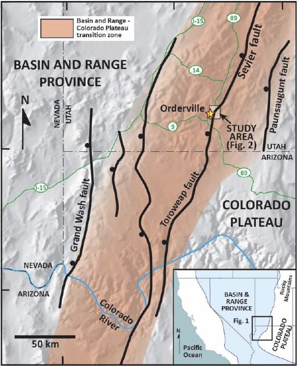
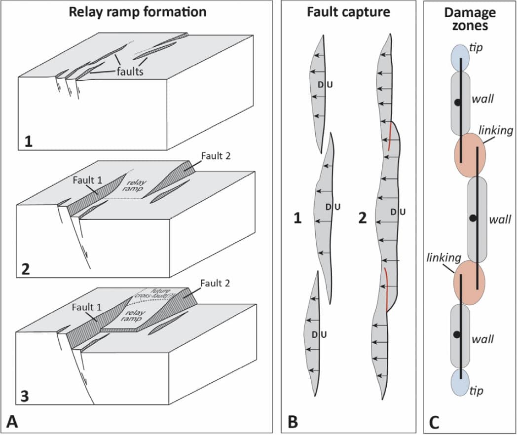
Geologic Overview The study area (Fig. 2) is part of a particularly complex portion of the Sevier normal fault, termed the Orderville geometric bend (e.g., Reber et al., 2001), with a range of transfer zone geometries exposed at different locations along the NNE-striking, west-dipping system. Figure 2 displays the fault network that accommodated extension along the Orderville bend, from the Elkheart Cliffs area in the south to the area north of Stewart Canyon. The bold yellow fault traces represent the dominant, high-displacement faults across the study area. The interaction of these fault systems is responsible for the formation of the relay ramps shown adjacent to Stewart Canyon and Red Hollow Canyon, and white faults represent lower-displacement normal fault systems that helped accommodate extension, likely evolving within the perturbed stress field associated with the transfer zones between dominant faults. Recent studies (e.g., Davis, 1999; Schiefelbein and Taylor, 2000; Schiefelbein, 2002; Doelling, 2008) and reconnaissance work by Trinity University undergraduates (Mathy et al., 2016; Simoneau et al., 2016) have revealed locations within the Orderville geometric bend that preserve fault geometries related to different stages of transfer zone evolution along the Sevier fault zone of southern Utah. These studies have also established a well-defined structural framework for detailed analysis of the subsidiary structures (e.g., relay ramps, minor faults, fractures, deformation bands) that form as synthetic normal fault segments propagate and link (Fig. 3).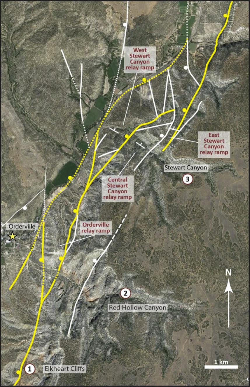
The geometry of vertical fracture propagation within fracture corridors
This student would use a combination of field data and SfM constructions of georeferenced virtual outcrop models. They would investigate how primary structures, including bed contacts, crossbeds, and crossbed‐set contacts affect the initiation, propataion, and termination of fractures. Because the models are georeferenced, they can directly measure distances to perform quantitative comparisons between different outcrops at different structural positions across the field area. The results of their investigation would shed light on the interplay of a developing fracture network in the context of both primary structures and structural position within a complex fault zoneStudy Area
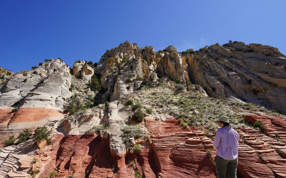
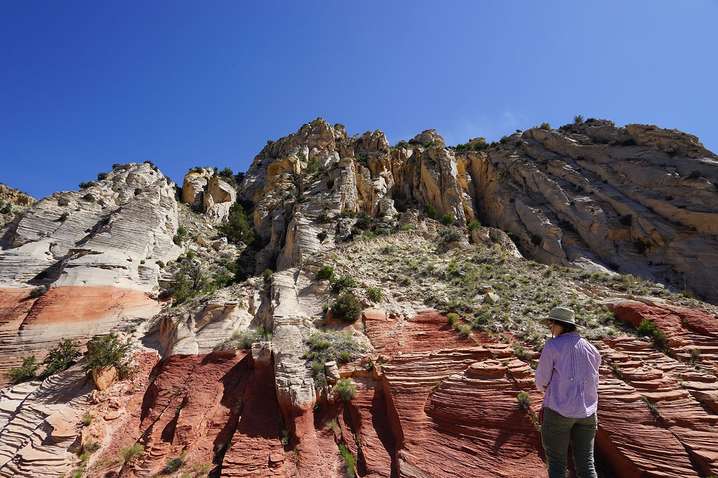
The excellent vertical and lateral exposure of the Jurassic Navajo and Temple Cap sandstones at the three primary study sites (Fig. 2) provides the opportunity to directly observe faults, fractures, and deformation bands within these well-studied lithologies (e.g., Rogers et al., 2004; Schultz et al., 2010; Solom et al., 2010), especially within the context of the mapped transfer-zone fault networks. The Elkheart Cliffs exposure at location 1 (Fig. 2) displays the simplest fault geometry because all E-W extension is accommodated by a single fault. In contrast, location 2 (Red Hollow Canyon) displays a more complex fault system with a single relay ramp, and location 3 (Stewart Canyon) displays the most complex fault network, including 3 relay ramps (Fig. 2). This spatial variation in fault complexity allows us to treat these locations as “snapshots” in time, capturing “moments” of growing fault zone complexity, permitting us to evaluate how the evolution of different fault geometries and complexities damages adjacent rock volumes (Fig. 3).
Goals and Significance of the Project
Our findings will shed light on how stress and strain in fault transfer zones vary spatially and evolve temporally across a range of scales. Because rocks in the study area are so well exposed, we can use results from this research to address the 3D evolution of rock volumes associated with similar fault zones in the subsurface. Brittle features, when formed in the subsurface, impact on the flow of fluids, including water and oil. Additionally, this research may reveal how strain is diffused at fault segment boundaries during earthquake events, thus impacting the assessment of seismic hazard in similar systems elsewhere. Related goals of this project include: 1) development of retro-deformable 2D and 3D models of the fault transfer zone, based on both published and new data, which we can test using industry-grade computer modeling software; 2) assessment of stress and strain fields, in the context of field data, that evolved during the vertical and lateral propagation of major fault segments using 3D computer modeling software; and 3) construction of a viable model of subsidiary structure formation in the context of rock properties and relative to the major fault segments mapped in the field. This project allows students to perform structural field research and computer modeling of a major, segmented normal fault in the regionally important transition zone between the eastern Basin and Range Province and the Colorado Plateau, and the ideas developed during this project will inform our understanding of the complex evolution of normal fault transfer zones worldwide.
Potential Student Projects
1. Structural evolution of the Orderville geometric bend, Sevier fault zone. This student would use published maps and new map data to construct accurate structural cross‐sections across the Orderville geometric bend. When combined with existing cross sections, this student can then construct a hypothetical 3D model of the fault system from surface to depth. An important part of this work would be to shed light on how faults in similar systems propagate and link both horizontally and at depth. If the student has access to the Move2020 software suite at their home institution, they can use the Fault Response Module to test their hypothesis(es). However, this project does not require computer modeling to be successful.
2. Predicting changes in strain accommodation associated with increasing fault zone complexity. Predicting changes in strain accommodation associated with increasing fault zone complexity. This student would use a combination of field data, structural analysis of faults and fractures, crosssection construction, and 3D modeling using the Move2020 Fault Response Module to investigate how total fault displacement changes along strike within the Orderville geometric bend (location 1 vs. location 2 vs. location 3). They would build 3 primary models, constrained by field and existing map data, to evaluate the characteristics of predicted fracture systems that develop in fault systems of varying complexity. When the student compares model results with field data and mapped fault patterns, they can develop hypotheses for strain accommodation and permeability development in rocks affected by fault systems of varying complexity. This project would require access to Move2020 during the academic year.
3. Predicting fault damage zones associated with horizontal propagation of overlapping normal faults. This student would use a combination of field data, mapped faults, fracture analysis, and SfM modeling (which permits constructions of a spatially‐accurate virtual outcrop model). This student would also likely use thin section petrography to document changes in both lithologic characteristics and fracture network characteristics in relation to faults with well‐constrained kinematics. In one case, fault segment displacement decreases from 10s of meters of displacement to 0‐m displacement (at the fault tip) over 100s of meters along strike (easternmost fault in Red Hollow Canyon, Fig. 2). Importantly, the rocks ahead of the fault tip are well exposed in the field, permitting students to evaluate damage in the fault tip zone during fault propagation. A student investigating these topics should be above to develop a model of fault propagation and fracture network development.
4. Changing stress-strain fields within a complex normal fault transfer zone. This student would use a combination of field data, mapped faults, fracture analysis, and 3D computer modeling using the Move2020 Fault Response Module to investigate how different fault geometries and overlaps affect the stress field and create subsidiary structures (mostly fractures). This student would choose several of the better constrained en echelon fault geometries (e.g., no overlap, some overlap, significant overlap, hard‐linked) to build and test 3D models of fracture development. This student would also likely use thin section petrography to document changes in both lithologic characteristics and fracture fill textures and compositions. These model results and petrographic analysis results could then be compared to field data, permitting the student to address how stress and strain vary in different cases of synthetic normal fault interactions.
5. Fault damage analysis within a complex normal fault transfer zone. This student would use a combination of field data, mapped faults, fracture analysis, and 3D computer modeling using Metashape Professional to investigate how fracture networks vary in cross‐sectional exposures of the fault network exposed in Stewart and Red Hollow Canyons (Fig. 2). These 3D models will be the virtual outcrops that this student can use to analyze changes in fracture intensities and orientations both horizontally Project Proposal: Structural Evolution of a segmented normal fault transfer zone, Sevier fault, southern Utah 9 (relative to mapped faults) and vertically (relative to changes in lithology). This student would also perform some petrographic analysis, especially investigating changes in lithology that might impact fracture development. The results of this student’s analysis would inform our understanding of fluid flow potential associated with similar fault networks in the subsurface.
6. The impact of primary structures on fracture network evolution. This student would use a combination of field data and SfM constructions of georeferenced virtual outcrop models. They would investigate how primary structures, including bed contacts, crossbeds, and crossbed‐set contacts affect the initiation, propataion, and termination of fractures. Because the models are georeferenced, they can directly measure distances to perform quantitative comparisons between different outcrops at different structural positions across the field area. The results of their investigation would shed light on the interplay of a developing fracture network in the context of both primary structures and structural position within a complex fault zone.
7. The geometry of vertical fracture propagation within fracture corridors. This student would use a combination of field data and SfM constructions of georeferenced virtual outcrop models. Fracture corridors are vertically‐oriented, tabular zones of high fracture intensity that may have a profound effect on the migration of fluids in the subsurface. In the study area, these corridors are commonly subparallel to the dominant fault segments but display no shear displacements. Our work during the 2018 Keck Advanced Project revealed many examples that should be easily analyzed by this student. The results from this study should permit the student to develop hypotheses about fracture corridor development on the outcrop scale as well as how these features might impact fluid flow in the context of transfer zone fault and fracture geometries.
PROJECT LOGISTICS
Field Work: Our tentative field dates are June 18 – July 5, 2022. Students will fly to San Antonio on June 17, and on June 18, the project team will depart San Antonio in 2 Trinity field vehicles, staying for one night in Albuquerque, NM, arriving at Bauer’s Canyon Ranch RV Park and Campground in Glendale, Utah, on the night of June 19. We will stay at Bauer’s Canyon Ranch RV Park from the night of the 19th until the night of July 3, performing fieldwork in the nearby canyons. We will purchase food in Orderville and prepare all meals in the RV park (which has shower and laundry facilities). During our time in the field, we will visit Zion National Park, where the same rock units are spectacularly exposed. Students will have access to power and wifi throughout our time at the RV park, so students can perform significant database building and field data analysis while in the field.
Students will be expected to carry medium-sized field packs with field equipment, lunches, and water every day in the field. Although hiking will be involved, we will not be hiking in rugged topography where safety is an issue. We will never be more than 2 miles from our field vehicle, and in most cases, we will not be more than 3 miles from a city or town. Although we will be performing fieldwork in late June, we will perform most fieldwork starting at 7 am and ending at about 2 pm, in order to avoid the hottest temperatures (commonly in the low- to mid-90s). In the afternoon, we will compile field data and discuss our findings in the context of the research questions. On July 3 – 5, we will drive back to San Antonio, TX, staying in Albuquerque, NM for one night.
Lab and Analytical Work: Students will work in the Geosciences department at Trinity University from July 5 – July 19, staying in Trinity’s dorms with other summer research students. Most dorms have kitchen facilities so meals can be prepared on campus. Many on-campus (non-Keck) research students will have access to cars, or alternatively, there is an on-demand hourly or daily car-rental system), so students can leave campus to purchase food. During this two-week period, all 4 students will focus on analyzing field data, cutting billets for thin sections, learning to use the 3D computer modeling software necessary for their project, and developing a research proposal and timeline for the rest of the academic year. Students will depart San Antonio on July 20.
PROFESSIONAL DEVELOPMENT
We plan to take all participants to the Geological Society of America meeting in Denver, CO (9–12 October 2022). We hope most students will be first author on one paper, and probably secondary authors on others due to the collaborative nature of the project.
All students are required to complete a 4-6 page paper (short contribution) that will be published in the Proceedings of the Keck Geology Consortium 2023 Volume (see examples from previous years). The first draft of this paper will be reviewed by your research advisor at your home institution sometime in late February, 2023, with the revised version sent to the project directors by March 1. Final versions of your paper and figures will be submitted to the Keck Office in Mid-March.
References
Anderson, R.E., and Christenson, G.E., 1989, Quaternary faults, folds, and selected volcanic features in the Cedar City 1°x2° quadrangle, Utah: Utah Geological and Mineral Survey Miscellaneous Publication 89-6, 29 p.
Anderson, J.J., and Rowley, P.D., 1987, Geologic map of the Panguitch NW quadrangle, Iron and Garfield Counties, Utah: Utah Geological and Mineral Survey Map 103, 8 p. pamphlet, scale 1:24,000.
Biddle, K.T., and Christie-Blick, N., 1985, Strike – slip deformation, basin formation, and sedimentation, In: Biddle, K.T., Christie-Blick, N., Eds.: Strike– Slip Deformation, Basin Formation, and Sedimentation. Society of Economic Mineralogists Special Publication, v. 37, p. 375– 386.
Crider, J., and Pollard, D., 1998, Fault linkage: Three-dimensional mechanical interaction between echelon normal faults: Journal of Geophysical Research, v. 103, p. 24,373 – 24,391.
Crone, A.J., and Haller, K.M., 1991, Segmentation and the coseismic behavior of Basin and Range normal faults: examples from east-central Idaho and southwest Montana, U.S.A.: Journal of Structural Geology, v. 13, p. 151– 164.
Davis, G., 1999, Structural geology of the Colorado Plateau region of southern Utah, with special emphasis on deformation bands: Geological Society of America Special Paper 342.
DeWitt, E., Thompson, J., and Smith, R., 1986, Geology and gold deposits of the Oatman district, northwestern Arizona: U.S. Geologic Survey Open-File Report 86-0638, 34 p.
Doelling, H.H., 2008, Geologic map of the Kanab 30’x60′ quadrangle, Kane and Washington Counties, Utah, and Coconino and Mohave Counties, Arizona, 1:100,000-scale: Utah Geological Survey, MP-08-2DM.
Doelling, H.H., and Davis, F.D., 1989, The geology of Kane County, Utah, with sections on petroleum and carbon dioxide by Cynthia J. Brandt: Utah Geological and Mineral Survey Bulletin 124, 192 p., scale 1:100,000, 10 plates.
Faulds, J., 1996, Geologic map of the Fire Mountain 7.5’ quadrangle, Clark County, Nevada, and Mohave County, Arizona: Nevada Bureau of Mines and Geology Map 106, scale 1:24,000 (with accompanying text).
Faulds, J., and Varga, R., 1998, The role of accommodation zones and transfer zones in the regional segmentation of extended terranes, In Faulds, J.E., and Stewart, J.H., Eds., Accommodation zones and transfer zones: the regional segmentation of the Basin and Range province: Geological Society of America Special Paper No. 343, p. 1 – 45.
Fonstad, M., Dietrich, J., Courville, B., Jensen, J., and Carbonneau, P., 2013, Topographic structure from motion: a new development in photogrammetric measurement: Earth Surface Processes and Landforms, v. 38, p. 421 – 430.
Goguel, J., 1952, Traite de Tectonique: Masson, Paris (Translated by Thalmann, H.E., 1962). Tectonics: Freeman Publishing Company, San Francisco, 384 p.
Hudson, M., 1992, Paleomagnetic data bearing on the origin of arcuate structures in the French Peak – Massachusetts Mountain area of southern Nevada: Geological Society of America Bulletin, v. 104, p. 581 – 594.
James, M.R., and Robson, S., 2012, Straightforward reconstruction of 3D surfaces and topography with a camera: Accuracy and geoscience application: Journal of Geophysical Research, v. 117, F03017, doi: 10 .1029/ 2011JF002289
Johnson, K., Nissen, E., Saripalli, S., Arrowsmith, R., McGarey, P., Scharer, K., Williams, P., and Blisnuik, K., 2014, Rapid mapping of ultrafi ne fault zone topography with structure from motion: Geosphere, v. 10, p. 969 – 986.
Kim, K.-S., Peacock, D., and Sanderson, D., 2004, Fault damage zones: Journal of Structural Geology, v. 26, p. 503–517.
King, G.C.P., and Nabalek, J.L., 1985, The role of bends in faults in the initiation and termination of earthquake rupture: Science, v. 228, p. 984 – 987.
Long, J., and Imber, J., 2011, Geological controls on fault relay zone scaling: Journal of Structural Geology, v. 33, p. 1790 – 1800.
Lund, W.R., Knudsen, T.R., and Vice, G.S., 2008, Paleoseismic reconnaissance of the Sevier fault, Kane and Garfield Counties, Utah: Utah Geologic Survey Special Study 122, Paleoseismology of Utah, v. 16, 31 p.Lowe, D., 2004, Distinctive image features from scale invariant keypoints: International Journal of Computer Vision, v. 60, p. 91–110, doi: 10 .1023 /B: VISI .0000029664 .99615.94.
Mathy, H., Surpless, B., and Simoneau, S., 2016, Testing models of en echelon normal fault evolution using 3D computer modeling: GSA National Meeting, Abstracts with Programs, Denver, Colorado.
Morley, C., Nelson, R., Patton, T., and Munn, S., 1990, Transfer zones in the East African Rift system and their relevance to hydrocarbon exploration in rifts: American Association of Petroleum Geologists Bulletin, v. 74, p. 1234 – 1253.
Peacock, D.C.P., 2002, Propagation, interaction and linkage in normal fault systems: Earth-Science Reviews, v. 58, p. 121 – 142.
Peacock, D.C.P., and Sanderson, D.J., 1996, Effects of propagation rate on displacement variations along faults: Journal of Structural Geology, v. 18, p. 311 –320.
Reber, S., Taylor, W., Stewart, M., and Schiefelbein, I., 2001, Linkage and Reactivation along the northern Hurricane and Sevier faults, southwestern Utah, In XXX, Eds., The Geologic Transition, High Plateaus to Great Basin – A Symposium and Field Guide, The Mackin Volume: Utah Geological Association Publication 30, Pacific Section American Association of Petroleum Geologists Publication GB78, p. 379 – 400.
Rogers, C., Myers, D., and Engelder, T., 2004, Kinematic implications of joint zones and isolated joints in the Navajo Sandstone at Zion National Park, Utah: Evidence for Cordilleran relaxation: Tectonics, v. 23, TC1007, doi:10.1029/2001TC001329.
Rowley, P., 1998, Cenozoic transverse zones and igneous belts in the Great Basin, Western United States: Their tectonic and economic implications In Faulds, J.E., and Stewart, J.H., Eds., Accommodation zones and transfer zones: the regional segmentation of the Basin and Range province: Geological Society of America Special Paper No. 343, p. 195-228.
Schiefelbein, I., 2002, Fault segmentation, fault linkage, and hazards along the Sevier fault, southwestern Utah [M.S. thesis]: Las Vegas, University of Nevada at Las Vegas, 132 p.
Schiefelbein, I., and Taylor, W., 2000, Fault development in the Utah transition zone and High Plateaus subprovince: Abstracts with Programs, v. 32, No. 7, p. 431.
Schultz, R., Okubo, C., and Fossen, H., 2010, Porosity and grain size controls on compaction band formation in Jurassic Navajo Sandstone: Geophysical Research Letters, v. 37, L22306, , doi:10.1029/2010GL044909.
Schwartz, D.P., and Coppersmith, K.J., 1984, Fault behavior and characteristic earthquakes – Examples from the Wasatch and San Andreas fault zones: Journal of Geophysical Research, v. 89, p. 5681 – 5698.
Shackleton, J., Cooke, M., and Sussman, A., 2005, Evidence for temporally changing mechanical stratigraphy and effects on joint-network architecture: Geology, v. 33, p. 101 – 104.
Simoneau, S., Surpless, B., and Mathy, H., 2016, The evolution of subsidiary fracture networks in segmented normal fault systems: GSA National Meeting, Abstracts with Programs, Denver, Colorado.
Solum, J., Brandenburg, J., Kostenko, O., Wilkins, S. and Schultz, R., 2010, Characterization of deformation bands associated with normal and reverse stress states in the Navajo Sandstone, Utah: AAPG Bull., v. 94, p. 1453–1475, doi:10.1306/01051009137.
Stewart, M., and Taylor, W., 1996, Structural analysis and fault segment boundary identification along the Hurricane fault in southwestern Utah: Journal of Structural Geology, v. 18, p. 1017 – 1029.
Stock, J., and Hodges, K., 1990, Miocene to recent structural development of an extensional accommodation zone, northeastern Baja California, Mexico: Journal of Structural Geology, v. 12, p. 312 – 328.
Tchalenko, J.S., 1970, Similarities between shear zones of different magnitudes: Bulletin of the Geological Society of America, v. 81, p. 1625–1640.
Thelin, G.P., and Pike, R.J., 1991, Landforms of the Conterminous United States – A Digital Shaded-Relief Portrayal: U.S.G.S. Geologic Investigations Series I – 2720.
Wallace, R.E., 1970, Earthquake recurrence intervals on the San Andreas fault: Bulletin of the Seismological Society of America, v. 81, p. 2875 – 2890.
Zhang, P., Slemmons, D.B., and Mao, F., 1991, Geometric pattern, rupture termination and fault segmentation of the Dixie Valley– Pleasant Valley active normal fault system, Nevada, U.S.A.: Journal of Structural Geology, v. 13, p. 165–176.