Rising waters, shrinking habitats: the influence of fluctuating water levels on the geology and ecology of a Great Lakes archipelago
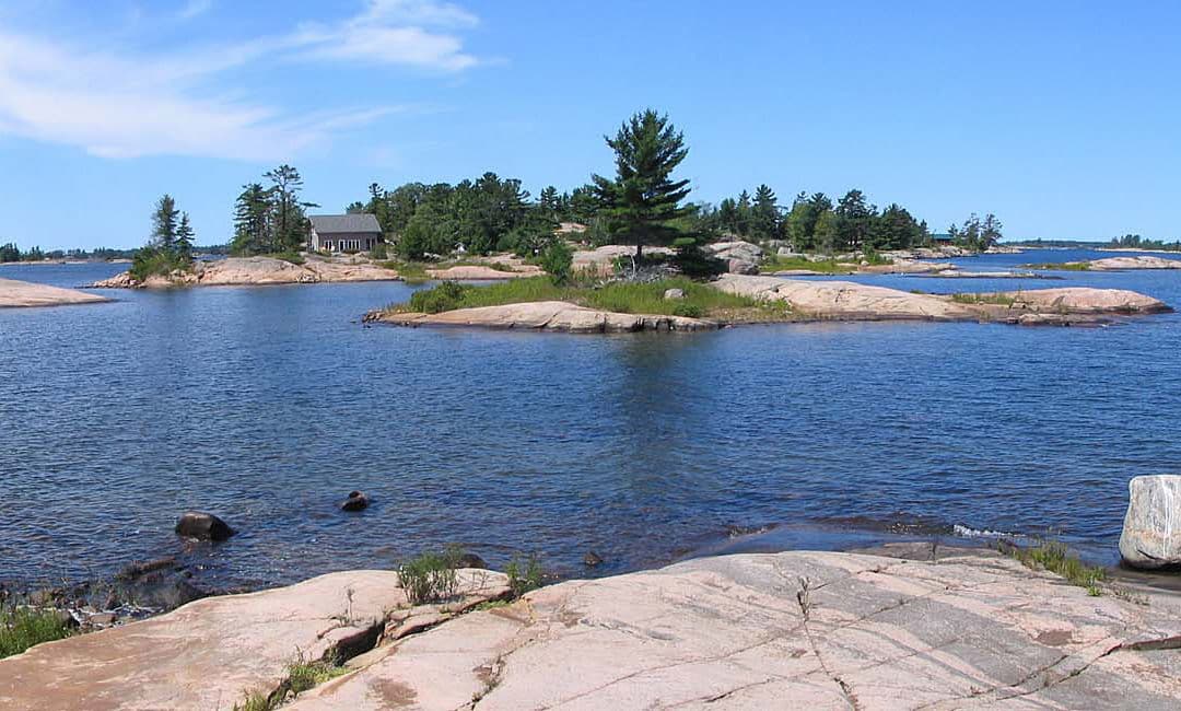
Overview: Global and regional environmental change has resulted in water-level changes in the world’s oceans and large lakes. Examination of the dynamic terrestrial-aquatic interface in the Great Lakes is pertinent to many of the conservation and policy issues in the region today. The Great Lakes have a history of water-level fluctuations (Figure 1). The lakes experienced an unprecedented extended period of declining water levels between 1999 and 2014. Record low water levels of the Michigan-Huron basin in 2013 (175.57 m asl) gave rise to near-record high levels in 2020 (177.45 m asl). (Note: the record high of 177.50 m asl occurred in 1986.) The fluctuating water levels influence the area and shoreline configuration of the islands as shorelines and low elevation islands emerge and submerge with these fluctuations. The project will investigate spatiotemporal changes in island shoreline configuration and plant biogeography within the Ontario Ministry of Natural Resources’ The Massasauga Provincial Park (Figure 2) on the eastern shore of the Georgian Bay by combining fieldwork data with the analytical tools of a geographic information system (GIS).
When: June 10 – July 15, 2021
Where: Online and Massasauga Provincial Park, Canada (if allowed)
Who: Four rising sophomores and project leader Dr. Kim Diver (kdiver@wesleyan.edu), Wesleyan University
Prerequisites and Recommended Courses: Enthusiasm to learn about new ways to study our planet. Introductory course in GIS will be advantageous, but not required.

Figure 1: Historical Monthly (light blue dots) and Yearly (dark blue line) Mean Water Level for the Lake Michigan – Huron Basin, 1918-2020. Note the prolonged low water period of 1999-2014. The vertical axis denotes lake level in meters above sea level (m asl). The red line indicates the average level (176.44 m asl) across the time period. Image source: Great Lakes Dashboard Project (https://www.glerl.noaa.gov/data/dashboard/GLD_HTML5.html).

Figure 2: Map of The Massasauga Provincial Park, Ontario, Canada. The park (green and red) consists of mainland and approximately 200 islands. Red islands are park islands sampled during 2001 (n = 34), 2006 (n = 19), 2011 (n = 17), and 2016 (n = 16), for a total of 45 islands.
PROJECT DESCRIPTION
Project goals and significance
Little is known regarding the role of feedbacks between climate patterns, coastline geomorphology, and shoreline vegetation on species richness patterns on islands. This project will combine spatial analyses, soil analyses, and ecological analyses to examine the interplay of regional climate, water levels, soils, and forest dynamics on plant species richness and composition patterns. The project has four main objectives: (1) create accurate island shoreline GIS data; (2) analyze the influence of water level changes on shorelines (e.g., island area, shape), island connectivity, and island ecosystems (plant species richness); (3) compare soil properties (e.g., soil pH, soil depth) among emerging/submerging substrates; and (4) examine spatiotemporal forest dynamics. Each of the project objectives will be analyzed in relation to vegetation surveys of plant species richness and composition to shed light on the applicability of the prevailing model of island biogeography in areas with fluctuating water levels.

Figure 3: Lake levels of the Michigan-Huron basin 1996-2020, showing levels during previous field seasons (2001, 2006, 2011, and 2016) in the Georgian Bay. The top (blue) and bottom (red) lines indicate record high and record low water levels, respectively, for the period of record (1918-2020). The vertical axis denotes lake level (m asl). The middle line (red) indicates the lake-wide average level (1918-2020). Image modified from Great Lakes Dashboard Project (https://www.glerl.noaa.gov/data/dashboard/GLD_HTML5.html).

Figure 4: The photographs from Florence Island taken in 2006 (left) and 2016 (right) show the difference in shoreline plant species composition and richness in a low (2006) and high (2016) water year. The yellow circles are drawn around the same tree to help orient the reader to the pocket bay on the island. The map depicts the differing island shape and size during the two years.
In the 20-year study period, four field seasons were during below average water level periods and the 2016 field season was during the recent period of above average lake levels (Figure 3). The range in percent change in island area for the study period 2001-16 was 11-55%. Water levels influence the area and connectivity of the islands as well as the nature of their shoreline habitats. Therefore, accurate island areas and shoreline configurations are needed to analyze predictors of plant species richness on islands in the Great Lakes. The changes in water levels alter the size and shape of the islands in the study area and, thus, could influence the number of plant species present on the islands (Figure 4). Studying the island biogeography of this archipelago over an extended time frame will allow for a better scientific understanding of ecological resilience in a system with unstable water levels. Data from 2021, which is projected to have above average water levels, is a crucial data year in the study.
The research project has many expected outcomes, including but not limited to:
- Increase scientific background and field training of undergraduate students. Participation in the project will allow students to gain training necessary for graduate work and careers in the geosciences, biogeography, and conservation ecology.
- Inform management decisions regarding the conservation of island ecosystems in the Great Lakes. Continued research in The Massasauga aids in the protection of vulnerable habitats and rare and endemic species. The spatial distribution analyses will lead to a better understanding of plant diversity on the islands. Biodiversity conservation benefits local species, but also benefits local residents through indirect ecosystem services such as maintenance of a healthy water cycle, contributions of plant respiration to air quality, etc.
- Benefit the international scientific community through a greater understanding of island ecosystems and the challenges that they face in the future. The project utilizes multifaceted approaches not hitherto studied within the scope of island biogeography theory. The results may shed light on the applicability of the prevailing model of island biogeography in areas of changing shoreline configuration and may contribute to a contemporary theory of island biogeography.
The proposed research has many expected outcomes, including but not limited to:
- Increase scientific background and field training of undergraduate students. Participation in the project will allow students to gain training necessary for graduate work and careers in the geosciences, biogeography, and conservation ecology.
- Inform management decisions regarding the conservation of island ecosystems in the Great Lakes. Continued research in The Massasauga aids in the protection of vulnerable habitats and rare and endemic species. For example, fluctuating water levels might influence the vulnerability of an island’s habitats to invasion by non-native plant species. Pinpointing variables most influential on non-native plant species dispersal and persistence might help park managers restrict the spread of these species, and ultimately lead to their eradication. The spatial distribution analyses will lead to a better understanding of plant diversity on the islands. Biodiversity conservation benefits local species, but also benefits local residents through indirect ecosystem services such as maintenance of a healthy water cycle, contributions of plant respiration to air quality, etc.
- Benefit the international scientific community through a greater understanding of island ecosystems and the challenges that they face in the future. The project utilizes multifaceted approaches not hitherto studied within the scope of island biogeography theory. The results may shed light on the applicability of the prevailing model of island biogeography in areas of changing shoreline configuration and may contribute to a contemporary theory of island biogeography. To my knowledge, previous studies of island biogeography have not considered the influence of fluctuating water levels on species richness and composition. Although the proposed research considers a freshwater system, the research findings are applicable to marine islands under threat of sea level rise. The proposed research will contribute to recent academic discussions calling for a revised theory of island biogeography that integrates new approaches.
Geologic setting
The Great Lakes contain the world’s largest collection of freshwater islands (Vigmostad 1999). The majority of these islands form dense archipelagos in the Canadian waters of Lake Huron’s Georgian Bay (Ontario). The Georgian Bay comprises the northwest portion of the Laurentian Great Lakes, separated from Lake Huron by the Bruce Peninsula and Manitoulin Island. The islands of The Massasauga are located within the UNESCO Georgian Bay Littoral Biosphere Reserve. The park consists of over 200 islands which approximate 2,000 hectares (ha) of landmass.
The Canadian Shield bedrock of The Massasauga consists of the Parry Sound Greenstone Belt (metavolcanic, metasedimentary, and igneous) and the Ontario Gneiss Belt, both of Precambrian origin (Cordiner 1977; Sly & Munawar 1988). The geologic belts show evidence of relict bedding and tectonic activity (e.g., folding, stacking, dikes, and lava flows) (Cordiner 1977; van Luit 1987; Larson & Schaetzl 2001). Several areas in the park have been identified for their unique geology including Vanderdassen Island, which contains the only calcareous metasedimentary rocks within the park not exposed to intense geological metamorphism as well as the only calcium-rich metasediments represented within the park (Ontario Ministry of Natural Resources 1993). For a detailed description and geological map, see Culshaw et al. (2004). As part of the Grenville Peneplain, the general elevation profiles of the islands are relatively flat, ranging from a few meters below lake level in depression basins to circa 50 m above lake level. Water depths between the islands range from less than a meter to depths in excess of 30 m.
The bedrock-dominated topography with thin, discontinuous sediments of glacial till and alluvium is due to bedrock erosion and substrate removal during periods of glacial abrasion and post-glacial lake wave-washing (Figure 5; van Luit 1987; Larson & Schaetzl 2001). The archipelago was formed by glacial scouring of the Canadian Shield, erosion from glacial meltwater drainages, and post-glacial isolation (Hirvonen & Woods 1978). Detailed reviews of glacial and postglacial lake level history of the Georgian Bay region are provided in Larson and Schaetzl (2001) and Eschman & Karrow (1985). During and following deglaciation, The Massasauga islands periodically emerged and submerged with high and low lake stands. Maximum lake levels during the postglacial Nipissing high lake stand (beginning 5.5 ka) reached 184 m asl, inundating the majority of the islands (even those currently greater than 184 m asl) due to lagging effects of isostatic depression (Eschman & Karrow 1985). The Massasauga islands permanently emerged as dry land 3-4 ka, following isostatic rebound and draining of the higher than present day lake levels associated with the postglacial Nipissing Great Lakes Periods (Hirvonen & Woods 1978). (Low elevation islands likely periodically emerged and/or immersed with post-Nipissing lake level fluctuations.) Lake levels for the past 2.5 ka show a stabilized mean of 177 m asl (Eschman & Karrow 1985).

Figure 5: Pomerdy Island exhibits the scoured bedrock typical of the region.
Potential student projects
Potential student projects revolve around issues of global environmental change at a local level. The projects listed below are subject to change due to student interest and data availability. Many of the projects can be conducted remotely.
Project 1. Island morphology and isolation (2-3 students). An increase in island area and a decrease in island isolation frequently correlate with an increase in species richness, and vice versa (MacArthur & Wilson). Previous studies in The Massasauga show that island area, island shape, and island isolation are the main drivers of the diversity of native plant species on islands within the archipelago (Diver 2004, 2008). GIS analyses using satellite imagery confirm that island shape and size change with fluctuating water levels (Figures 4 and 6). The expectation is that islands that decrease in size and/or increase in isolation with high water levels should correlate with less plant species presence. Students will map and analyze species richness data in relation to other data (e.g. island area, isolation, elevation). Research questions include: (1) How have island morphology and isolation changed over the twenty-year study period? (2) How do spatiotemporal changes in island morphology and isolation correlate to changes in plant species richness? (4) Can we model future changes in island morphology and plant species diversity/richness based on low- and high-water scenarios?
Project 2. Soil assessment (1 student). Determining the spatial heterogeneity of soil characteristics (e.g., pH, organic matter, nutrients) in relation to the spatial heterogeneity of shoreline substrates is important in predicting habitat diversity and, thus, species richness patterns on the islands in response to fluctuating water levels. The expectation is that soil pH and other soil properties differ significantly between recently emerged and established substrates, which could play an important role in interisland patterns of plant species composition and richness. The student will analyze soils data in relation to other variables (e.g., soil depth, shoreline emergence, species richness, etc.) in ArcGIS. Scientific questions include: (1) Are there inter- or intra-island variations in soil properties? (2) Is soil heterogeneity a predictor of plant species richness?

Figure 6: Map of Forage Island depicting the difference in island size and shape due to differences in lake levels in 2013 (175.57 m asl) and 2016 (176.84 m asl).
Project 3. Stand dynamics (1 or 2 students). Longitudinal studies of repeat plant inventories allow for a more in-depth examination of shifting plant species compositions and transitions in forest dynamics over time (Diver 2010). Examination of the population structures of tree species can be a time-efficient method to discern likely temporal shifts in plant species richness (Parker 1992). Student(s) will assess stand structure by creating size-class structures, calculating tree importance values, and characterizing species population structures for the sampled islands. The student(s) will analyze the data in relation to other variables (e.g., results of the soil analyses, species richness, etc.) in to examine general profiles of regeneration trends and future changes in overstory and understory plant species richness. Research questions include: (1) Can the size-class structures yield information about overstory dominance and regeneration trends? (2) Can the dominance and regeneration trends be correlated to lake level regimes?

Figure 7: The dead standing white pine trees are approximately 15 years old. White pines established on islands in the study area during an extended period of below average lake levels beginning in 1999. (The shoreline in the 2001 and 2006 field seasons was to the right of the green shrubs.) Following a rise in water levels in 2014, the author found the dead trees during the 2016 field season – illustrating the need for repeated plant inventories in island biogeography research.
Project 4. Non-native plant species (1 student). Non-native plant species are typically early colonizers and efficient reproducers, thereby outcompeting native plant colonizers on newly emerged shorelines. The student will use the island morphology and isolation data in conjunction with species presence/absence data to analyze spatiotemporal trends in non-native plant species over the twenty-year study period. Research questions include: (1) How do spatiotemporal changes in island morphology and isolation correlate to changes in non-native plant species richness? (2) Do non-native plant species respond differently than native plant species to fluctuating island morphologies? (3) Can we model future changes in island morphology and non-native plant species diversity/richness based on low- and high-water scenarios?
Project 5. Lake ice cover (1 student). The relationship between lake ice and lake levels is complex, involving multiple variables including ice coverage, ice duration, lake thermal structure, surface evaporation, wind and water current patterns, and basin-wide precipitation. The surface coverage and duration of lake ice varies annually and monthly. The student will use existing ice cover data for the Great Lakes and use historic satellite images to refine the data for the study area over the twenty-year study period to analyze spatiotemporal changes in lake ice cover. Research questions include: (1) Is there yearly ice cover variability in the study area? (2) Does local ice cover variability correlate with water level variability?
Project 6. Shoreline mapping (1 student). Shorelines in The Massasauga are varied (e.g., steep cliff, sandy beach, cobble shore) and therefore affect the colonization and persistence ability of plants differently. The student will use drone imagery and satellite imagery to create maps of shoreline character and elevation. Research questions include: (1) Is there a relationship between shoreline character and lake level caused changes in island morphology? (2) Is there a relationship between bedrock type and relief? (3) Is there a relationship between shoreline character and plant species richness?
Learning Outcomes
This project will enable students to use field data and spatial data to examine the dynamics of coastlines faced with environmental change. Specific learning outcomes include:
- Students will gain foundational knowledge of global environmental change, coastline dynamics, ecological conservation, and island biogeography.
- Students will gain intermediate GIS skills.
- Students will learn to read and interpret topographic maps and satellite imagery.
- Students will learn to collect data from vector and raster GIS datasets, with an understanding of why the data are important/interesting to the long-term goals of the study.
- Students will learn how to process field data and to integrate field data with GIS data for mapping and analyzing spatiotemporal data within a GIS.
- Students will learn how to be effective team members.
- If a fieldwork component transpires, then students will learn field data collection techniques (e.g., map and compass use, plant taxonomy and voucher specimen collection, island perimeter delineation using GPS, drone mapping, soil collection, sample preparation, standard soil tests).
PROJECT LOGISTICS
Project dates are 10 June – 15 July 2021. Much of the project will take place remotely with frequent meetings on Zoom. In the first week, students will learn relevant GIS skills (in ArcGIS Pro) and orient themselves to the study site and existing data sets. During this introductory week, students can develop their ideas for the individual portions of the project. In subsequent weeks, students will be given the data sets necessary to continue the analyses for their individual components.
If world events allow for a field component, it will occur at The Massasauga Provincial Park during the second and third weeks of the project. Base camp will be on the mainland with daily boat trips to individual islands. For students participating in the field component, students are expected to find their own transportation to the base camp and back. (Base camp is approximately 2 hours north of the Toronto Pearson International Airport.) Students must have appropriate documentation for crossing the US-Canada border. Depending on availability, students will be housed in a cabin or camp in a tent. Food preparation will be as a group. Students must provide their own life jacket and personal items (e.g., sunscreen, sleeping bag, etc.).
Safety issues for students participating in the field component
The Massasauga Provincial Park is a remote boat-access only park. Participants in the field work component will be informed of boating safety (e.g., wear life jackets, VHF radio use, map navigation) and potential hazards on the islands. Common terrestrial hazards include off-trail obstacles (e.g., cliffs) and flora and fauna (e.g., poison ivy, rattlesnakes, ticks). Students should be prepared for working in challenging field conditions and be comfortable with boating on open water and with bushwhacking in wooded environments. Students must be able to swim.
Planning for the COVID-19 Era
Below are five possible contingency plans. With the current COVID-19 conditions, Plan C or E appears most likely/feasible.
Plan A: fieldwork component for everyone. In this scenario, each of the students will work remotely for three weeks of the project (one week before fieldwork and two weeks after fieldwork) and participate in the fieldwork component for two weeks.
Plan B: fieldwork component for part of the group. In this scenario, each of the students will work remotely for three weeks of the project (one week before fieldwork and two weeks after fieldwork) and 1-2 students participate in the two-week fieldwork component. During the fieldwork weeks, students not in the field will continue to work remotely.
Plan C: no fieldwork component. In this scenario, the entire project is virtual. Students will use 2021 satellite imagery to collect shoreline data and other variables. Research questions that require field data will be modified to accommodate the use of data from the 2001-16 field seasons.
Plan D: in person field and GIS components for everyone.
Plan E: fieldwork component for faculty member only. In this scenario, the faculty member could collect field data and disseminate the data to the group for processing and analysis.
PROFESSIONAL DEVELOPMENT
One of the important outcomes of the project will be a synthesis of the individual components into a conference publication at the American Association of Geographer’s (AAG) annual meeting. The annual meeting is the main conference of the AAG and brings together physical geographers from across the world. Students can present posters of their individual projects and contribute to a co-authored oral presentation that synthesizes the group’s work. The conference will have multiple professional development opportunities for the students such as engagement with physical geographers, participation in peer mentoring sessions regarding career paths, and attendance at hands-on skills workshops.
References
Cordiner, G.S. 1977. A Reconnaissance Earth Science Inventory of Blackstone Harbour Provincial Park Reserve. Algonquin Region: Division of Parks, Ontario Ministry of Natural Resources.
Culshaw, N.G., D. Corrigan, J.W.F. Ketchum, P. Wallace, N. Wodicka, and R.M. Easton. 2004. Georgian Bay geological synthesis, Grenville Province: Explanatory Notes for Preliminary Maps P.3548 to P.3552. Ontario Geological Survey, Open File Report 6143, 28p.
Diver, K.C. 2004. Biogeography of Island Flora in the Georgian Bay, Lake Huron, Ontario, Ph.D. Dissertation, Syracuse University, Syracuse, NY.
Diver, K.C. 2008. Not as the crow flies: assessing effective isolation for island biogeographical analysis. Journal of Biogeography 35:1040–1048.
Diver, K.C. 2010. Beyond area and isolation: Forest dynamics and change in plant species richness patterns on islands. Annals of the Association of American Geographers 100: 1110-1127.
Eschman, D.F. & P.F. Karrow. 1985. Huron basin glacial lakes: a review. In Quaternary Evolution of the Great Lakes (ed. by P. Karrow and P. Calkin). Geological Association of Canada Special Paper 30.
Hirvonen, R. & R.A. Woods. 1978. Georgian Bay Islands National Park Integrated Resource Survey. Forest Management Institute, Ottawa.
Larson, G. & R. Schaetzl. 2001. Origin and evolution of the Great Lakes. Journal of Great Lakes Research 27:518-546.
MacArthur, R.H. & E.O. Wilson. 1967. The Theory of Island Biogeography. Monographs in Population Biology. No. 1. Princeton: Princeton University Press.
Ontario Ministry of Natural Resources. 1993. The Massasauga Provincial Park Management Plan. Government of Ontario: http://files.ontario.ca/environment-and-energy/parks-and-protected-areas/mnr_bpp0406.pdf.
Parker, A.J. 1992. Spatial variation in diameter structures of forests in Lassen Volcanic National Park, California. The Professional Geographer 44:147–60.
Sly, P.G. & M. Munawar. 1988. Great Lake Manitoulin: Georgian Bay and the North Channel. Hydrobiologia 163:1-19.
van Luit, H. 1987. Blackstone Harbour: Management Plan Background Information Document. Ontario Ministry of Natural Resources, Division of Parks, Parry Sound, Ontario.
Vigmostad, K.E, editor. 1999. State of the Great Lakes Islands. Paper read at US-Canada Great Lakes Islands Workshop, 1996, at Roscommon, Michigan.