Unraveling the controls on channel form and geomorphic history in northern Yellowstone National Park, Wyoming
Overview: We will analyze the controls on fluvial processes and determine the geomorphic history of two streams in northern Yellowstone National Park. Documentation and analysis of the geomorphic history of streams in northern Yellowstone is essential for understanding how a trophic cascade caused by the removal and reintroduction of wolves may have altered stream behavior in the 20th century. To assess stream behavior during the historical period, it is necessary to quantify baseline natural stream variability during the Holocene. Along Blacktail Dear Creek, we will map terrace/floodplain landforms and measure channel geometry. The timing of sedimentation on terraces and floodplains will be studied using radiocarbon dating and short-lived radionuclides. On the Gallatin River, we will survey channel cross sections throughout the drainage basin to investigate hydraulic geometry and environmental controls on channel form.
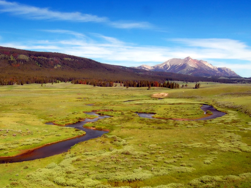
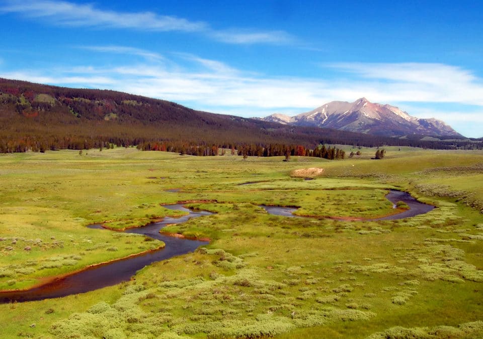
Figure 1: Streams in the Northern Range provide key riparian habitat in the relatively dry lower elevations of Yellowstone National Park.
When: July 22 – August 24, 2019
Where: We will meet in Walla Walla, WA. From Walla Walla, we drive to Yellowstone National Park and spend three weeks performing field work. We will return to Walla Walla for 1 week of work in the lab. From Walla Walla, students will return to their home institutions.
Who: A team of 4 students and Dr. Lyman Persico, Whitman College (persiclp@whitman.edu)
Prerequisites and Recommended Courses: A course in earth surface processes (geomorphology) and sedimentology will be most useful. Other useful courses include paleoclimatology, ecology, and any field-based classes. What is most important, however, is a passion for working out of doors and a willingness to tackle unpredictable problems that always present themselves while doing field work. Applicants should have an interest in interdisciplinary research at the intersection of geology and ecology. Applicants must be willing to spend long days collecting field data in one of the most beautiful places on Earth, and spend the evenings discussing fluvial geomorphology and camping. Students wanting to use this work for a senior thesis will have preference. Letters of reference should speak to the applicant’s ability to work independently and their potential for both field and laboratory research.
Expectations and Obligations:
1. Participation in all project-related work during the summer (July 22-Aug 24).
2. Data analyses at home institution and regular conference calls with the research team throughout the academic year.
3. Write an abstract and present a poster at the Rocky Mountain sectional meeting of the Geological Society of America in Utah Valley, UT (May 4-5 2020).
4. Expected but not required: Use the research for a senior thesis (or equivalent).
PROJECT DESCRIPTION
Introduction and Rationale
Riparian corridors are key ecological zones in semiarid regions, as they provide abundant water and food resources and are typically more biologically diverse than the overall landscape. These corridors are particularly important in the relatively dry Northern Range of Yellowstone National Park (Yellowstone National Park, 1997). The Northern Range is synonymous with the winter range of the northern Yellowstone Elk herd. The Northern Range (Fig. 1 and 2) is relatively dry (mean annual precipitation: 350-500 mm) and the low-elevation region is dominated by sagebrush-grasslands with scattered conifer groves. In the early 20th century, many streams in the Northern Range hosted abundant beaver and beaver dams (Warren, 1926). Beaver are considered a keystone species of riverine-riparian ecosystems (Naiman et al., 1988b) as beaver dams elevate water tables, expand riparian habitat, increase aquatic productivity, and store more groundwater (Naiman et al., 1986; Naiman et al., 1988a; Pollock et al., 1995; Gurnell, 1998; Anderson et al., 2006; Westbrook et al., 2006; Gribb, 2007; Cooke and Zack, 2008; Brzyski and Schulte, 2009; Green and Westbrook, 2009). Beaver dams also reduce stream velocity and induce sedimentation in channels and on floodplains (Butler and Malanson, 1995). It has been hypothesized that the long-term effect of beaver damming may substantially aggrade valley floors (Ruedemann and Schoonmaker, 1938; Ives, 1942). More recent research using radiocarbon dating, however, has shown that there are limits on the net aggradation of beaver damming to less than 3 meters (Persico and Meyer, 2009; Polvi and Wohl, 2012; Persico and Meyer, 2013).

Figure 2: Blacktail Deer Creek and the Gallatin River drain portions of the Washburn and Gallatin ranges, respectively. The proposed study will focus on lower elevation stream reaches that receive less snow and are considered elk winter range.
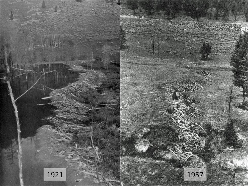
Figure 3: The Northern Range stream of Elk Creek contained many beaver dams in the 1920s that extended across much of the valley floor. Those beaver dams were abandoned by the 1920s and the stream has incised over 2 m from the top of the beaver bond sediments.
Interestingly, beaver have been largely absent from the Northern Range since the mid-20th century (Fig. 3, Jonas, 1955). The causes of beaver decline and associated riparian zone changes have been debated in both the scientific literature and popular press over the past three decades (Yellowstone National Park, 1997; National Research Council, 2002). It has been proposed that Northern Range streams experienced an ecosystem state switch from beaver-willow to elk-grasslands during the latter half of the 20th century (Wolf et al., 2007). According to some, the loss of beaver is the direct result of competition from elk (Chadde and Kay, 1991). Elk populations increased dramatically in the 20th century due to the extirpation of wolves by hunting. Large elk populations have led to over-browsing of willow and other riparian vegetation. Mature aspen and riparian tall-willow stands, important food resources for beaver, have declined since park establishment, but aspen were never abundant in historic or Holocene time (Houston, 1982; Whitlock and Bartlein, 1993; Romme et al., 1995).
The loss of beaver and elk browsing have potentially caused significant alterations to Northern Range streams. The loss of beaver dams have caused channels to incise and floodplain abandonment (Fig. 3, Wolf et al., 2007; Beschta and Ripple, 2018). Channel incision has also caused the lowering of water tables, which limits willow and aspen growth (Marshall et al., 2013). These changes serve to disconnect channels from floodplains thereby reducing riparian areas (Marshall et al., 2013), however preliminary results indicate that at least some stream incision in the Northern Range predates the historical period (Fig. 5, Persico and Meyer, 2009). Additionally, the decreased riparian vegetation has led to widespread degradation of stream and riparian habitat via channel widening by bank erosion (Chadde and Kay, 1991; Beschta and Ripple, 2006; Wolf et al., 2007).
Regardless of changes to vegetation structure in Northern Range riparian communities, there are other factors that control channel form and stream dynamics including flow properties, bank material, subsurface conditions, and climatic variability (Knighton, 1998). In the greater Yellowstone ecosystem, climate variability is a significant factor in the long-term history of channel dynamics (Meyer, 2001; Persico and Meyer, 2009, 2013). Channel response to forest-fire related sedimentation is another important control on channel morphology in YNP (Meyer et al., 1992; Meyer et al., 1995; Legleiter et al., 2003). Although there is abundant research on the ecological dynamics of the Northern Range, relatively little research has focused on the stream channel and valley floor itself (Fig. 4). For example, there is little research that has attempted to differentiate terrace and floodplain deposits using geochronologic methods. Both Blacktail Deer Creek and the Gallatin River are sites where there is much discussion of the impacts of trophic cascades on channel dynamics (Beschta and Ripple, 2006; Beschta and Ripple, 2018). The proposed research is an important contribution to the study of the magnitude and extent of the effects of trophic cascades, which has even made it to the popular press in recent years (Robbins, 2005; Chadwick, 2010).
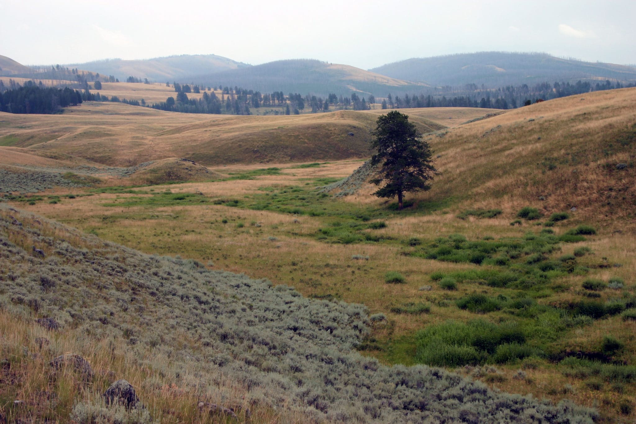
Figure 4: Blacktail Deer Creek drains the northern flanks of the Washburn Range. The stream has an inset floodplain. It is not clear how much of the valley floor is a Holocene terrace or historical floodplain that has been more recently abandoned.
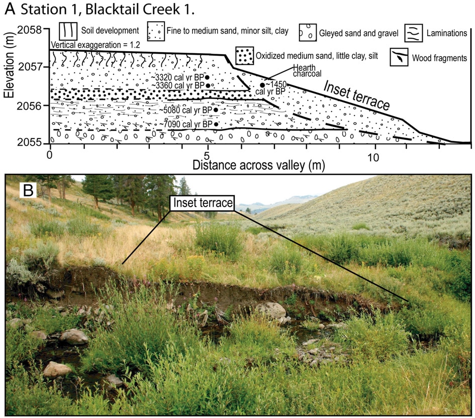
Figure 5: On the east fork of Blacktail Deer Creek a sediments in a terrace ~1.5 above the modern floodplain accumulated 7-3 ka and incision commenced ~1.5 ka (Persico and Meyer, 2009). It is unknown how widespread this surface is or its relationship to the historical floodplain proposed by Bescthta and Ripple (2018).
Proposed Research: The primary goal of this project is to determine the environmental controls on channel form and fluvial dynamics on two streams in northern Yellowstone. This work will expand on the previous research on channel forms in Yellowstone (e.g. Meyer et al., 1995; Meyer, 2001; Legleiter et al., 2003; Persico and Meyer, 2009) and focus on detailed measurements of valley floor and channel morphology. The primary goal will be accomplished through mapping of terrace/floodplain surfaces, characterizing terrace/floodplain deposits, and estimation of the timing of floodplain/terrace aggradation.
On Blacktail Deer Creek, we will combine high-resolution RTK GPS measurements with geomorphic mapping to produce surficial geologic maps of terrace and floodplain surfaces (Fig. 4). On Blacktail Deer Creek glacial erosion and modification of topography has resulted in diverse fluvial valley widths and gradients, so that very gentle to steep channels exist across the entire range of contributing basin areas. Thus, the relationship between hydrologic and geomorphic controls and channel morphology can be fully examined. The stratigraphy and soil development in terrace deposits will be described in detail. Sediment samples will be collected from the sediments for laboratory analyses of grain size and organic content. Charcoal and wood fragments will be collected for 14C dating. The youngest ages of organic material that can be dated using 14C is 1950 due to above ground nuclear testing that has “spiked” the amount of 14C in the atmosphere since that time. Additionally, significant variability of atmospheric14C in the past 100-200 years has created a radiocarbon plateau, which produces significant errors when calibrating these young ages (Fig. 7). We will supplement the timing of sediment deposition via14C with short-lived radionuclides (Goldberg and Koide, 1962; Krishnaswami et al., 1980). We will collect sediment samples and estimate concentrations of atmospherically-derived 137CS and 210Pb in both terrace and floodplain sediments. These analyses allow for a more detailed analysis of sedimentation rates in the past several hundred years (Whiting et al., 2005; Soster et al., 2007).
On the Gallatin River, the goal of the proposed research is to characterize downstream changes to the geometry of the active channel. The Gallatin River drains the western flank of the Gallatin Range. The upper reaches of the river are outside of elk winter range providing a control for streams in northern Yellowstone that have not been influenced by elk overbrowsing. A series of cross sections will be measured by RTK GPS and supplemented by a total station when necessary. The geometry of channels will be combined with surficial and geologic maps to determine geologic controls on channel forms, which can be compared to environmental controls such as elk browsing. In the lab, cross sections will be used to estimate the hydraulics of floods along the river using HEC-RAS modeling.
Potential Student Projects
Project 1: Mapping of channel, floodplain, and terrace landforms along Blacktail Deer Creek. This student project will use a combination of survey data and surficial geologic mapping to produce a highly detailed map of fluvial landforms along the valley floor. Features will be mapped with <0.25m vertical precision using both an RTK GPS and total station. Coring analysis of up to 18 trees located on terrace surfaces will help to constrain the age of the floodplain and terrace surfaces. In the lab the student will use ARCGIS to analyze the magnitude of incision and percentage of the valley floor that is comprised of the different surfaces.
Project 2: Characterization of floodplain/terrace sediments and estimation of the timing of deposition by radiocarbon dating. This student project will focus on the deposit of terraces and floodplains. Field activities will include recording detailed stratigraphic and soil horizon observations and sampling the sediments and organic material preserved in the sediments (Fig 6). Estimation of the timing of deposition of terrace surfaces will be made by dating charcoal and wood preserved in overbank deposits. Laboratory activities at Whitman College will include using the laser diffractometer to measure sediment sizes, identifying wood type, and preparing samples of modern root samples to send to Direct AMS for14C analyses. I will work with the student and the home advisor for analysis of the ages in including calibration.
Project 3: Characterization of floodplain/terrace sediments and estimation of the timing of deposition by short-lived radionuclides. This student project will focus on the same terrace and floodplain stratigraphy of Project 2. The use of the short-lived radionuclides 147Cs and 210Pb will be used to determine terrace and floodplain stability. Field activities include recording detailed stratigraphic and soil horizon observations and sampling the sediments and organic material preserved in the sediments. Sediment samples will be collected from locations where multiple terrace and floodplain surfaces are present. Short cores will be collected using a push corer. Laboratory activities at Whitman College will consist of measuring the organic content of sediments using Loss on Ignition (LOI) and processing the cores by subsampling each core at 5 cm intervals. These sub samples will be sent to Oberlin College for determination of 210Pb and147Cs concentrations. The student will work with me, and Amanda Schmidt at Oberlin on analyzing the isotope data.
Project 4: Measuring downstream changes in hydraulic geometry of the Gallatin River. This student project will focus on characterizing the hydraulic geometry of the Gallatin River. Field activities will include collecting a series of cross sections in and above elk winter range. This student project will analyze a series of cross sections. Laboratory activities include developing a simple 2D hydraulic model using HEC-RAS. This model will allow the student to assess where there has been recent incision of the channel.
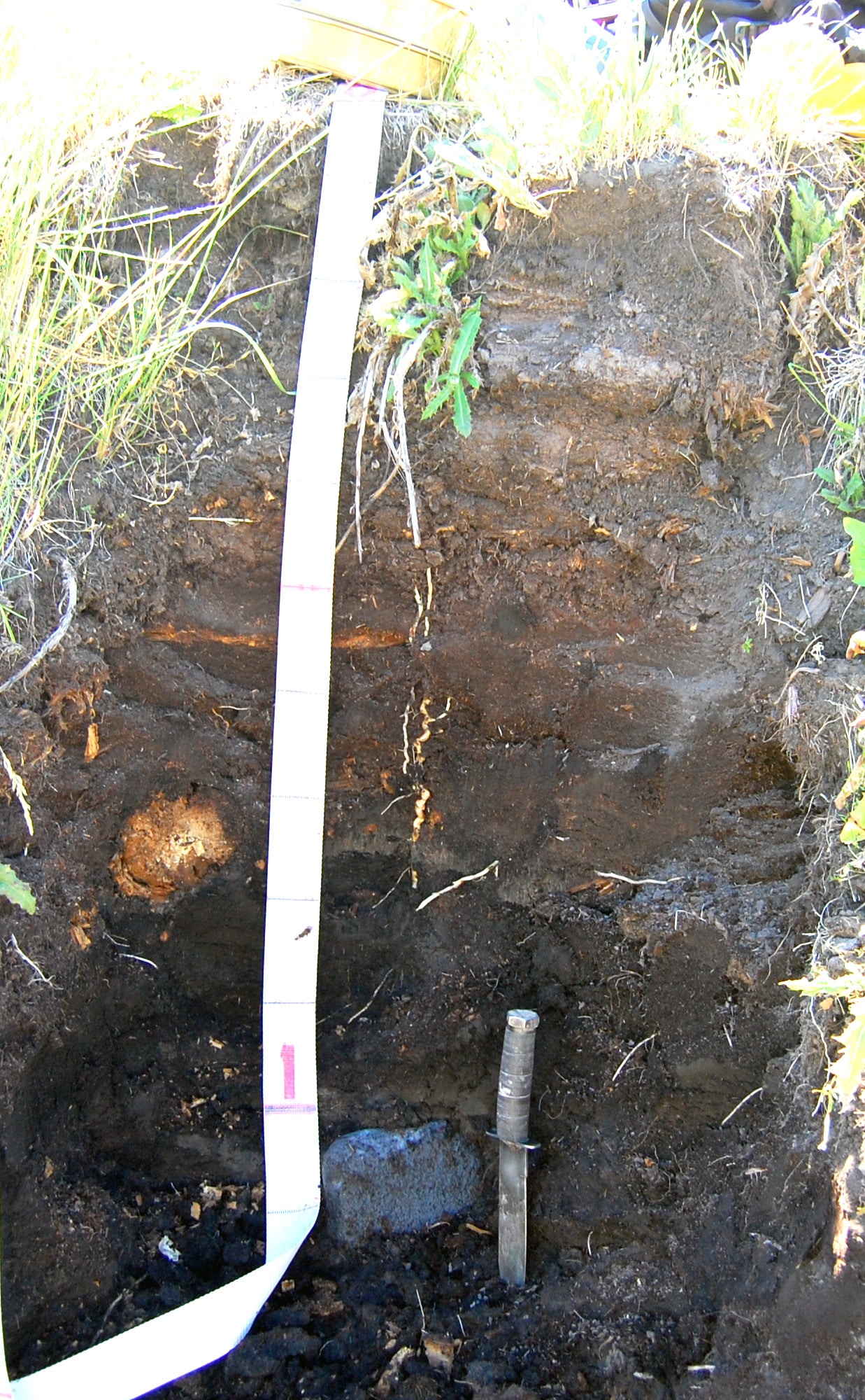
Figure 6: Terrace deposit on Blacktail Deer Creek with abundant woody material for 14C dating. The stratigraphy and soil development will be described in the field. Samples will be collected for 14C, organic content, and grain size analyses.
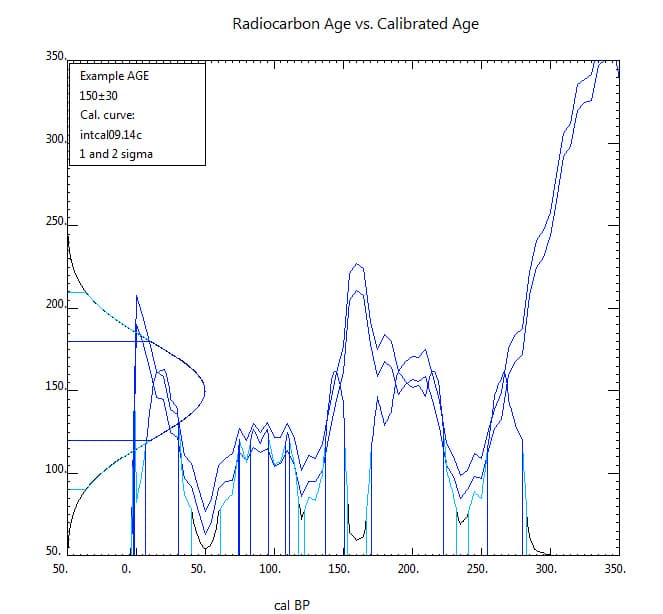
Figure 7: Calibration age of a hypothetical 14C age of 150 years. Due to a radiocarbon plateau, this simple has high probability of any time in the past 300 years.
PROJECT LOGISTICS
Students will arrive in Walla Walla on July 22. We will spend two nights on Whitman Campus. We will prepare for the field work in the science building on July 23 and leave for Yellowstone on July 24. While in Yellowstone we will first stay north of the Park, near Gardiner, MT. We will likely camp at the Eagle Creek campground, although, the campground is first-come-first-serve, so the backup plan is to stay at the Jardine campground, which is more remote and not as likely to fill up. We will stay at Eagle Creek for 14 nights while performing all field work on Blacktail Dear Creek. Most meals will be prepared at the campsite on camp stoves borrowed from the Whitman College. We will resupply and do laundry in the town of Gardiner. For field work on the Gallatin River we will most likely stay at the Rainbow Point campground on Hebgen Lake.
Students will need to be able to carry a medium-sized field pack and field equipment every day. We will also pack water and lunch each day. We will be hiking up to six miles per day. Most of the hiking will be on the valley floor, thus relatively low gradients. We will also be surveying stream cross sections. This will require multiple river crossings.
Research Schedule:
Phase 1 (7/22-7/25) Travel and Introduction
- Arrive in Walla Walla
- Crash course in methods of fluvial geomorphology
- Risk assessment and mitigation discussion
- Pack
- Travel to Yellowstone
Phase 2 (7/26-8/9) Blacktail Deer Plateau Field Work
- Mapping and survey of terrace and floodplain surfaces
- Terrace deposit stratigraphic descriptions and sampling for radiocarbon
- Sediment Core sampling for short-lived radionuclides
Phase 3 (8/10-8/19) Gallatin River Field Work and Travel
- Mapping and survey of terrace and floodplain surfaces
- Drive to Walla Walla
Phase 4 (8/20-8/24) Laboratory Analyses
- Prepare and ship wood/charcoal samples for radiocarbon analyses
- Prepare and ship sediment samples for short-lived radionuclide analyses
- Begin analyses of cross section and mapping data
Phase 5 (4-5 May 2020) Professional Development
- Poster presentations at Rocky Mountain GSA
Safety:
There are risks inherent to field research. These risks include physical injuries such as broken bones and sprained ankles. Other risks include venomous snakes, dehydration, heat stroke, sunburn, and mosquito bites. These risks will be mitigated by following proper field and wilderness protocols. Professor Persico has extensive field and wilderness experience as a field camp instructor and outdoor recreation trip leader. Professor Persico will hold a safety meeting in Walla Walla to explain the risks and the strategies that will be employed to mitigate these risks. Another risk in Yellowstone are bears. Professor Persico has 10 seasons of field experience with Yellowstone bears. Bear spray is the standard bear deterrent in YNP. We will be working mostly at low elevations, where black bears are more common (Grizzly bears claim the higher elevations farther away from humans during the summer). Black bears are less of a hazard compared to Grizzly Bears (much less aggressive). Professor Persico will talk about bear safety before the field work. This will include watching a You Tube video of the proper procedure for using bear spray. Each member of the team will have a can of bear spray. Additionally, while in the field I will use the time-honored tradition of banging one’s shovel against rocks when hiking.
PROFESSIONAL DEVELOPMENT
Professor Persico will take all participants to the Rocky Mountain section meeting of the Geological Society of America in Utah Valley, Utah (4-5 May 2020). Each student will prepare their own first-authored abstract with the other students as collaborators.
All students are required to complete a 4-6 page paper (short contribution) that will be published in the Proceedings of the Keck Geology Consortium 2019 Volume (see examples from previous years). The first draft of this paper will be reviewed by your research advisor at your home institution sometime in late February, 2019, with the revised version sent to the project directors by March 1. Final versions of your paper and figures will be submitted to the Keck Office in Mid-March.
References
Anderson, C.B., Griffith, C.R., Rosemond, A.D., Rozzi, R., Dollenz, O., 2006. The effects of invasive North American beavers on riparian plant communities in Cape Horn, Chile – Do exotic beavers engineer differently in sub-Antarctic ecosystems? Biological Conservation 128, 467-474.
Beschta, R.L., Ripple, W.J., 2006. River channel dynamics following extirpation of wolves in northwestern Yellowstone National Park, USA. Earth Surface Processes and Landforms 31, 1525-1539.
Beschta, R.L., Ripple, W.J., 2018. Can large carnivores change streams via a trophic cascade? Ecohydrology 0, e2048.
Brzyski, J.R., Schulte, B.A., 2009. Beaver (Castor canadensis) Impacts on Herbaceous and Woody Vegetation in Southeastern Georgia. American Midland Naturalist 162, 74-86.
Butler, D.R., Malanson, G.P., 1995. Sedimentation rates and patterns in beaver ponds in a mountain environment. Geomorpholo 13, 255-269.
Chadde, S.W., Kay, C.E., 1991. Tall-willow communities on Yellowstone’s Northern Range: A test of the “natural-regulation” paradigm, in: Keiter, R.B., Boyce, M.S. (Eds.), The Greater Yellowstone Ecosystem. Yale University Press, Binghamton, pp. 231-263.
Chadwick, D.H., 2010. Wolf Wars, National Geographic.
Cooke, H.A., Zack, S., 2008. Influence of beaver dam density on riparian areas and riparian birds in shrubsteppe of Wyoming. Western North American Naturalist 68, 365-373.
Goldberg, E.D., Koide, M., 1962. Geochronological studies of deep sea sediments by the ionium/thorium method. Goeochemica Cosmochemica Acta 26, 417-450.
Green, K.C., Westbrook, C.J., 2009. Changes in riparian area structure, channel hydraulics, and sediment yield following loss of beaver dams. Journal of Ecosystems and Management 10, 68-79.
Gribb, W., 2007. Beaver (Castor canadensis) impacts and characteristics on stream hydrology and vegetation in the Snake River Drainage System, Grand Teton National Park, Wyoming. United States Department of the Interior, Report on file, National Park Service, Moose WY.
Gurnell, A., 1998. The hydrogeomorphological effects of beaver dam-building activity. Prog. Phys. Geogr. 22, 167-189.
Houston, D.B., 1982. The northern Yellowstone elk. Macmillian, New York, NY.
Ives, R., 1942. The beaver-meadow complex. Journal of Geomorphology 5, 191-203.
Jonas, R.J., 1955. A population and ecological study of the beaver (Castor canadensis) of Yellowstone National Park. University of Idaho, p. 193.
Knighton, D., 1998. Fluvial Forms and Processes A New Perspective. Oxford University Press, New York.
Krishnaswami, S., Benninger, L.K., Aller, R.C., Von, Damm, K.L., 1980. Atmospherically derived radionuclides as tracers of sediment mixing and accumulation in near-shore marine and lake sediments—Evidence from 7Be, 210Pb, and 239,240Pu. Earth and Planetary Science Letters 47, 307–318.
Legleiter, C., Lawrence, R., Fonstad, M., Marcus, W., Aspinall, R., 2003. Fluvial response a decade after wildfire in the northern Yellowstone ecosystem: a spatially explicit analysis. Geomorpholo 54, 119-136.
Marshall, K.N., Hobbs, N.T., Cooper, D.J., 2013. Stream hydrology limits recovery of riparian ecosystems after wolf reintroduction. Proceedings of the Royal Society B-Biological Sciences 280.
Meyer, G.A., 2001. Recent large-magnitude floods and their impact on valley-floor environments of northeastern Yellowstone. Geomorpholo 40, 271-290.
Meyer, G.A., Wells, S.G., Balling, R.C., Jull, A.J.T., 1992. Response of alluvial systems to fire and climate change in Yellowstone-National-Park. Nature 357, 147.
Meyer, G.A., Wells, S.G., Jull, A.J.T., 1995. Fire and alluvial chronology in Yellowstone National Park: Climatic and intrinsic controls on Holocene geomorphic processes. Geological Society of America Bulletin 107, 1211-1230.
Naiman, R.J., Johnston, C.A., Kelley, J.C., 1988a. Alteration of North-American streams by beaver. Bioscience 38, 753-762.
Naiman, R.J., Johnston, C.A., Kelly, J.C., 1988b. Alteration of North American streams by beaver. Bioscience 38, 753-762.
Naiman, R.J., Melillo, J.M., Hobbie, J.E., 1986. Ecosystem alteration of boreal forest streams by beaver (Castor-canadensis). Ecology 67, 1254-1269.
National Research Council, 2002. Ecological Dynamics on Yellowstone’s Northern Range. National Academy Press, Washington DC.
Persico, L., Meyer, G., 2009. Holocene beaver damming, fluvial geomorphology, and climate in Yellowstone National Park, Wyoming. Quaternary Res 71, 340-353.
Persico, L., Meyer, G., 2013. Natural and historical variability in fluvial processes, beaver activity, and climate in the Greater Yellowstone Ecosystem. Earth Surface Processes and Landforms 38, 728-750.
Pollock, M.M., Naiman, R.J., Erickson, C.A., Johnston, C.A., Paster, J., Pinay, G., 1995. Beaver as engineers: influences of biotic and abiotic characteristics of drainage basins, in: Jones, C.G., Lawton, J.H. (Eds.), Linking species and ecosystems. Chapman and Hall, New York, pp. 117-126.
Polvi, L.E., Wohl, E., 2012. The beaver meadow complex revisited – the role of beavers in post-glacial floodplain development. Earth Surface Processes and Landforms 37, 332-346.
Robbins, J., 2005. Hunting Habits of Wolves Change Ecological Balance in Yellowstone, New York Times, New York, NY.
Romme, W.H., Turner, M.G., Wallace, L.L., Walker, J.S., 1995. Aspen, elk, and fire in northern Yellowstone National Park. Ecology 76, 2097-2106.
Ruedemann, R., Schoonmaker, W., 1938. Beaver-dams as geologic agents. Science 88, 523-525.
Soster, F.M., Matisoff, G., Whiting, P.J., Fornes, W., Ketterer, M., 2007. Floodplain sedimentation rates in an alpine watershed determined by radionuclide techniques. Earth surface processes and landforms 32, 2038-2051.
Warren, E.R., 1926. A study of the beaver in the Yancey region of Yellowstone National Park. Roosevelt Wildlife Annals 1, Syracuse.
Westbrook, C.J., Cooper, D.J., Baker, B.W., 2006. Beaver dams and overbank floods influence groundwater-surface water interactions of a Rocky Mountain riparian area. Water Resources Research 42, 2005WR004560.
Whiting, P.J., Matisoff, G., Fornes, W., 2005. Suspended sediment sources and transport distances in the Yellowstone River basin. Geological Society of America Bulletin 117, 515-529.
Whitlock, C., Bartlein, P.J., 1993. Spatial variations of Holocene climatic change in the Yellowstone region. Quaternary Res 39, 231-238.
Wolf, E.C., Cooper, D.J., Hobbs, N.T., 2007. Hydrologic regime and herbivory stabilize an alternative state in Yellowstone National Park. Ecological Applications 17, 1572-1587.
Yellowstone National Park, 1997. Yellowstone’s Northern Range: Complexity and Change in a Wildland Ecosystem. National Park Service, Mammoth Hot Springs.