Paleoenvironmental analysis of ancient (petro)calcic soil horizons: disentangling climatic, geomorphic, and biological records in the Mojave Desert
Overview: This four-student project will test a suite of related hypotheses regarding the mineralogical, morphological, and geomorphic history of Mormon Mesa, NV, a 5-4 million year old Mojave Desert landform containing a complex carbonate-cemented (petrocalcic) soil profile. The Mormon Mesa soil serves as an important and fascinating analog for other calcic and petrocalcic soils around the world, as well as for paleosols in the stratigraphic record. This work will expand upon past research by using stable isotope geochemistry alongside detailed soil-stratigraphic and micromorphological descriptions to constrain the relative timing, climate context (e.g., pluvial versus interpluvial), formation history and durability of horizon components including laminae, concretions, and cemented matrix across the Mormon Mesa soil profile, and especially within its morphologically complex “massive” horizon (Brock and Buck, 2009). This project will produce the first stable isotope data from Mormon Mesa’s unique soil, and it will afford important, publishable new tests of closed-system assumptions for the use of isotope geochemistry and geochronology in (petro)calcic horizons and paleosols worldwide.
Sampling soil in the Mojave Desert
When: June 18-July 13, 2018
Where: Claremont, California (introduction and lab work) and Mormon Mesa, Nevada (field work)
Who: Four students and project leader Dr. Colin Robins (Claremont McKenna College, crobins@kecksci.claremont.edu)
Prerequisites and Recommended Courses: Suggested (but not required) are (1) a topical course from among Soil Science, Geomorphology or Quaternary Geology, and (2) core courses in the Geology major such as Mineralogy, Historical Geology, and Stratigraphy. Some background in chemistry is also recommended, whether through an Introductory Chemistry sequence or through a course such as Geochemistry, Environmental Chemistry, or Petrology. Applicants should have an interest in soil science and/or geomorphology, be willing to work in a few days of extreme heat, should also be interested in learning how to patiently master advanced laboratory analytical equipment. Preference will be given to students hoping to use this work for a senior thesis or capstone. Helpful, but not required in the letter of recommendation from the on-campus sponsor is an indication of the applicant’s ability to work independently. Also helpful for comment are the student’s propensity for careful description, attention to detail in laboratory work, and ability to hold up in trying field conditions.
Expectations and Obligations:
- Participation in all project-related work during the summer (June 18-July 13, 2018).
- Sample preparation, analytical work, and interpretation with a research advisor at the student’s home college
- Co-author an abstract and (co-)present a poster for the Geological Society of America Meetings in Indianapolis, IN, November 4-7, 2018.
- Write a short contribution (4-6 pages text + figures) to be published in the Proceedings of the Keck Geology Consortium 2019 Volume (first draft due Mid-February).
- Expected but not required: Use this work for the completion of a senior thesis (or equivalent) at your home institution. Potentially help convert the study into a manuscript for peer-reviewed journal publication down the road.
PROJECT DESCRIPTION
Geologic Overview Soils are fascinating geological features that reflect the complicated dynamics of climate, organisms, Earth materials, and surface processes over long (103 to 106) time spans. In deserts especially, small magnitude precipitation or temperature shifts can impart large magnitude responses in soil chemistry, mineralogy, and profile morphology (Chadwick and Chorover, 2001). Soils and regolith developed in humid climates largely reflect the hydrolysis of primary minerals and the loss of soluble cations from the Earth’s surface, but arid soil profiles instead reflect a net gain of ions via dust and rainfall over time (Gile et al., 1981). Combined with strong alkalinity and high potential evapotranspiration, this solute influx yields a diversity of environmentally sensitive, pedogenic mineral assemblages including carbonates, sulfates, nitrates, and chlorides, and phyllosilicates such as smectite, palygorskite, and sepiolite (Dixon and Weed, 1989; Brady & Weil, 2008; Graham et al., 2008; Brock-Hon et al., 2012; Robins et al., 2012). Each of these minerals, some quite rare, serves as a marker of its own narrow range of soil chemical conditions. Tantalizingly, invaluable paleoenvironmental data may therefore be coded into the isotopic or elemental geochemistry of each pedogenic mineral. Vexingly, this authigenic record can be easily biased or erased by subsequent cycles of soluble mineral dissolution and recrystallization, or even skewed by unrecognized lithogenic contamination (Brock and Buck, 2005; Kraimer and Monger, 2009; Robins et al., 2014). Careful work is sorely needed to identify and to model the linkages between geochemistry, mineralogy, profile morphology, and regional geomorphology before conducting meaningful isotopic analysis of arid soil/paleosol minerals. Given predicted climate change trends, it is imperative to better constrain rates of soil geomorphic processes in arid and semi-arid landscapes, which comprise a third of Earth’s terrestrial environments and marginally support up to two billion people. Soils and paleosols characterized by pedogenic carbonate (mainly calcite and low-Mg calcite) accumulation are perfect subjects for such research. Carbonate-cemented soil horizons cap geomorphic surfaces in modern, arid to semi-arid landscapes worldwide, and they also mark unconformities in the stratigraphic record (e.g., Reeves, 1976; Machette, 1985; Retallack, 2001). Under steady environmental conditions, pedogenesis drives progressive morphological evolution of the soil from soft calcic horizons (stage I & II) to hard petrocalcic horizons (indurated, stage III-VI; sometimes informally called “calcrete” or “caliche”) driving positive feedbacks with landscape hydrology (Gile et al., 1966; Bachman and Machette, 1977; Machette, 1985). Rates of carbonate pedogenesis vary widely with climate and parent material; calcic horizons can prove more complex than assumed. Precise, local models are needed on a site-by-site basis to link mineralogical and soil structural (micromorphological) evolution to regional geomorphic histories (e.g., Alonso-Zarza et al., 2002; Brock and Buck, 2009). Critically, isotopic data can and must be used to validate site-specific models. Isotopic analysis of pedogenic CaCO3 (δ13C and δ18O), phyllosilicates (δ18O) , and barite (δ34S and δ18O) from different soil developmental stages can yield useful insights into paleovegetation (e.g., Deutz et al., 2001), paleotemperature (Quade et al., 2013), microbial activity (e.g., Jennings and Driese, 2014), and more.
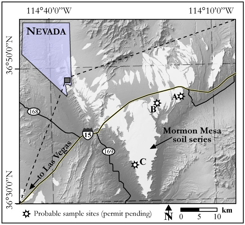
Figure 1: Location of the Mormon Mesa soil geomorphic surface (Soil Survey Staff, 2006) in southern Nevada. Proposed sample locations include (A) Riverside, (B) Halfway Canyon, and (C) Logandale. Basemap data modified from USGS (2005).
Mormon Mesa, Nevada (Fig. 1) hosts perhaps the oldest, extant petrocalcic soil profile in North America. The landform poses a rich set of questions for paleoenvironmental and geochronologic research. Due to its extreme age and relatively restricted spatial extent, Mormon Mesa is even a possible candidate for rare/endangered soil classification. Mormon Mesa’s sequence of three to four petrocalcic (Bkkm) horizons caps sediments of the Miocene-Pliocene Muddy Creek Formation (MCF) (Fig.2) (Gardner, 1972; Brock and Buck, 2009). Within the soil, pedogenic laminae, pisoliths (e.g., irregular, > 2mm concretions indicative of rotation), dissolution voids and other features (Fig. 3) reflect episodes of calcite precipitation, horizon brecciation, and re- cementation (Brock and Buck, 2009). MCF deposits are fluvial and eolian sediments deposited in a closed basin prior to incision of the Virgin River upon interception by the lower Colorado River (Kowallis and Everett, 1986; Williams et al., 1997). The uppermost MCF strata exhibit pedogenic carbonate nodules (stage II calcic horizon). Onset of pedogenesis at Mormon Mesa is thus considered synchronous with incision of the lower Colorado River system ~5.6 – 4.2 Ma (Faulds et al., 2002; House et al., 2005). A 5-4 Ma age for the Mormon Mesa surface is further supported by regional stratigraphic and morphostratigraphic correlation with isotopically dated tuffs and basalts (Schmidt et al., 1996; Williams et al., 1997; Faulds et al., 2002). Incision produced ~200 m of relief between the mesa’s surface and the modern floodplain (Fig. 2). Combined with an overall arid to semi-arid climate history, incision is hypothesized to have stopped interaction of the soil with groundwater, however, stable isotope data are needed to confirm this long-standing assumption. The Mormon Mesa soil has been previously described and variably interpreted (Gardner, 1972; Bachman and Machette, 1977; Soil Survey Staff, 2006). Its current soil geomorphic model was developed by Brock and Buck (2009), and models for its mineral evolution (Robins et al., 2012) and the genesis of its pedogenic ooids (Robins et al., 2015) have been recently published as well. Nonetheless, the polygenetic nature of this soil and the complexity of its micro-morphological and mineralogical architecture warrant further study, especially regarding the relative timing of authigenic mineral crystallization. None of the published models have ever been validated with stable isotope data. Detailed elemental geochemical comparisons have not been made for individual minerals between horizons nor between micromorphological features (e.g., laminae, pisoliths, matrix, dissolution voids). Finally, the potential of the soil for geochronology appears low (e.g., Robins et al., 2014) but has not yet been fully evaluated. Importantly, models developed at Mormon Mesa may be cautiously applied to many other calcic and petrocalcic horizons and paleosols worldwide.
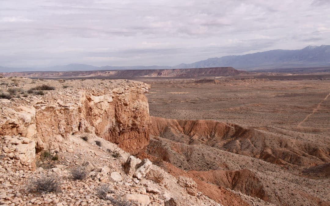
Figure 2(A): Mormon Mesa soil-geomorphic surface (view from “Riverside” site, looking to the northeast), with white petrocalcic (calcrete) horizons capping red sediments of the Muddy Creek Formation (MCF); ~200 vertical meters separate the top of Mormon Mesa from the Virgin River channel, right (southeast). (B): Mormon Mesa soil profile at “Riverside” site, showing the “Brecciated” (surface) horizon atop the “Massive” stage VI petrocalcic and “Transitional” stage III horizons (transitional to stage II MCF paleosols). Horizon nomenclature from Brock & Buck (2009).
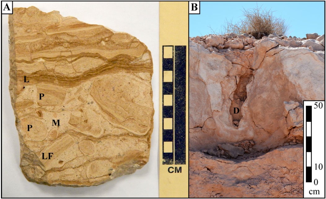
Figure 3(A): Polished sample of the Massive horizon (“Riverside” site); evident micromorphological features include laminae (L), brecciated laminar fragments (LF), pisoliths (P), and undifferentiated carbonate-cemented matrix (M). Each feature class may yield distinct isotopic signatures (Image from Robins et al., 2015). (B): Large dissolution pipe (D) in the massive horizon at the “Logandale” site.
Goals and Significance of the Project Isotopic analyses of calcic and petrocalcic soils are increasingly being used for geochronology and/or paleoenvironmental reconstruction (temperature, precipitation, vegetation), however, the suitability of discrete mineral and micromorphological components for these analyses is not guaranteed, needs to be evaluated on a case-by-case basis, and bears more detailed consideration overall. The goal of this project is to use stratigraphy, geomorphology, (micro)morphology, mineralogy, and geochemistry as corroborative data sets with which to test a suite of related hypotheses regarding the relative age and closed-system behavior of calcic soil minerals and micromorphological components (laminae, matrix, ooids). This work is significant and needed to expand and to refine our understanding of arid soil pedogenesis (past, present, and future) and the response of arid soil landforms to environmental change. Four related but independent student projects will be chosen by Dr. Robins and the students from among the options below.
Potential Student Projects
- Dissolution Characterization (1-2 students): Dissolution pits, pipes, and extensive fractures scar the horizons of Mormon Mesa and other late-stage carbonate soils. Some features are joint-like, anecdotally thought to be formed by earthquakes and then enhanced by rooting and infiltration. The origin of others is less clear. Importantly, dissolution represents corruption or isotopic resetting of CaCO3 and it is the primary reason why numerical dates for petrocalcic horizons remain problematic. A project to describe, measure , and define dissolution features, and to distinguish dissolution under subaerial conditions from dissolution within-profile would be impactful for an international community of researchers. Such work entails: (1) profile description at the Riverside and Logandale sites (Figure 1), and description of case hardening at Halfway Canyon (an active arroyo with groundwater calcrete), accompanied by concurrent, new (2) sampling of (a) surface clasts, (b) rinds along dissolution zones within the massive horizon, and (c) groundwater calcrete, (3) micromorphological description of clasts and dissolution rinds via (a) optical microscopy and (b) SEM-EDS (for microkarst), and (4) δ13C and δ18O from transects across clasts (2 per site) and rinds (2 per site). This project could dovetail with clay mineral research(below) as pedogenic clays may coat pit bottoms after carbonate dissolution.
- Phyllosilicate Mineralogy (1 student): Palygorskite and sepiolite are fibrous, Mg-phyllosilicates formed in calcic and petrocalcic horizons via chemical solution feedbacks with calcite, silica, and barite, (Robins et al., 2012). Elements to build these clays are supplied by force of crystallization dissolution of primary silicates by calcite (Watts, 1980; Robins et al., 2012), and by alteration of lithogenic illite or smectite. Palygorskite and sepiolite pervade Mormon Mesa’s horizons, however, some features contain a greater abundance of them than others. Importantly, the lattice structure of palygorskite and sepiolite may provide long-term microporosity to explain the measurable water holding capacity of petrocalcic horizons (Duniway et al., 2007). A study is needed to (1) quantify palygorskite/sepiolite abundance and (2) assess their geochemical variability across the full soil-stratigraphic section from MCF sediments up through surface eolian sands. Separating clays from indurated, calcite overgrowths is time-consuming, but the student would begin with isotopic, XRD, and geochemical analysis of archived samples, then tackle samples from the MCF, transitional and surface horizons while dissolving samples of the massive and brecciated horizons. Analysis of δ18O in clays from each micromorphological feature type would help definitively assign climate context to those features.
- Differentiation of Matrix, Pisoliths, and Laminae (1-2 students): Beginning perhaps by 5 Ma, and certainly by the Pleistocene, weakly cemented ancestral calcic horizons containing nodules, clast pendants, calcified fungal filaments or rhizo-concretions, and strongly indurated ancestral petrocalcic horizons containing massively indurated matrix, laminae, and concretions were partially or completely eroded and redeposited by flash floods reworking the Mormon Mesa surface. Fluvial and/or eolian sands reburied these fragments, which were then re-cemented by subsequent pedogenesis. Thus, Mormon Mesa’s horizons are a kind of pedogenic conglomerate in which clasts are fragments of widely varied calcic horizon stages and ages. Research is needed to: (1) describe the type and spatial context of fragments throughout the soil profile, (2) measure the relative abundance of detrital silicates and pedogenic calcite, sepiolite/palygorskite, barite, and amorphous silica in distinct components of each horizon, and (3) determine whether calcite in each feature records distinct or similar isotopic signatures, to test existing models (Brock and Buck, 2009).
- Barite neoformation (1 student): Barite is generally considered insoluble in alkaline soils (Lynn et al., 1971; Kabata-Pendias, 2011), yet authigenic barite has formed in the Mormon Mesa massive horizon (Brock et al., 2012). Barite’s solubility can double with each tenfold increase in ionic strength from Na and Cl (e.g., Stoops and Zavaleta, 1978; Blount, 1977; Sullivan and Koppi, 1993; Hanor, 2000), and Mg also increases Ba solubility in alkaline pH. Thus, Mg depletion from soil solutions during sepiolite or palygorskite crystallization under slightly saline interpluvial climates could drive barite precipitation, explaining the close spatial association between barite and these clays (Brock-Hon et al., 2012). Thus, barite may be an important marker of soil chemical and hydrological processes and it may eventually prove common in many other old, extant petrocalcic soils around the world. An project on this topic will employ δ18O and δ34S analysis of barite separates to test hypotheses regarding: (1) Ba mobilization during drier, interpluvial climates when solutions are more saline, and (2) the role of microbial processes in supplying sulfate for mineralization (Brock-Hon et al., 2012). Alternatively, (3) hollandite, a Ba-Mn oxide found in desert varnish and dust throughout the U.S. Southwest could be investigated as a hypothesized source for Mormon Mesa’s Ba. Hollandite could be sought in the eolian sand dunes and ramps on and surrounding Mormon Mesa. Ba, Mn, Mg, and Na relationships could be tested via soluble element analysis across the soil profile.
- Pedogenic Ooids (1 student): Pedogenic ooids have been documented in the Mormon Mesa soil, and they are known from other calcic soils (Bachman & Machette, 1977). This project would be designed to test models of ooid genesis (Robins et al., 2015) against their occurrences in and absences from specific soil horizons and micromorphological features. This project would improve models of soil profile development and help constrain the relative timing of specific pedogenic processes.
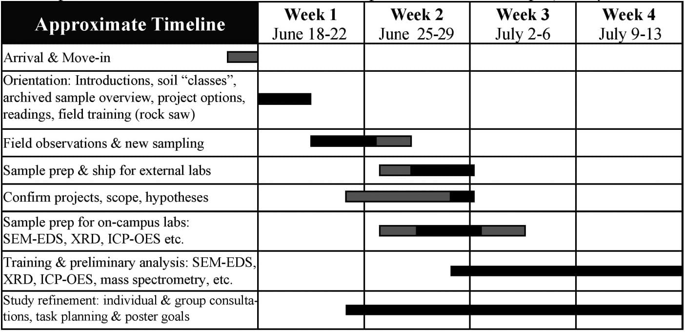
Figure 4.
PROJECT LOGISTICS
Overview: Figure 4 lays out a rough timeline for the first four weeks of the project. Students will meet in Claremont for a few days of orientation, geological background, soil science training, and project discussion before we drive to field sites for soil-stratigraphic description and sampling at Mormon Mesa. We will return to Claremont to prep samples for analysis (on campus, back at the students’ home campuses, as well as at external laboratories), to train on analytical equipment, and to refine hypotheses based on field observations and preliminary analysis. Students will complete their project and their literature review at their home institutions.
Field Work: Students must be willing to start field work at first light, eat in the heat, get to bed early and responsibly, and to endure several days of significant heat (90 – 115°F) while remaining on task with detailed soil-stratigraphic description, sketching, photographing, and sampling. Long sleeved light-weight clothing (zip-off pant legs are ideal) and a desert-appropriate hat are mandatory.
Analytical Work: Students will train in Claremont in order to be able to independently complete laboratory data collection and interpretation at their home institution according to expectations and established soil science method protocols. Some samples will be prepped for isotopic analysis by external laboratories, though students will be exposed to stable isotope analytical methods at Pomona College. Training will include exposure to rock crushing and grinding equipment, an XRF spectrometer, an XRD spectrometer, a field-emission SEM, an ICP-OES, and a new stable isotope mass spectrometry laboratory.
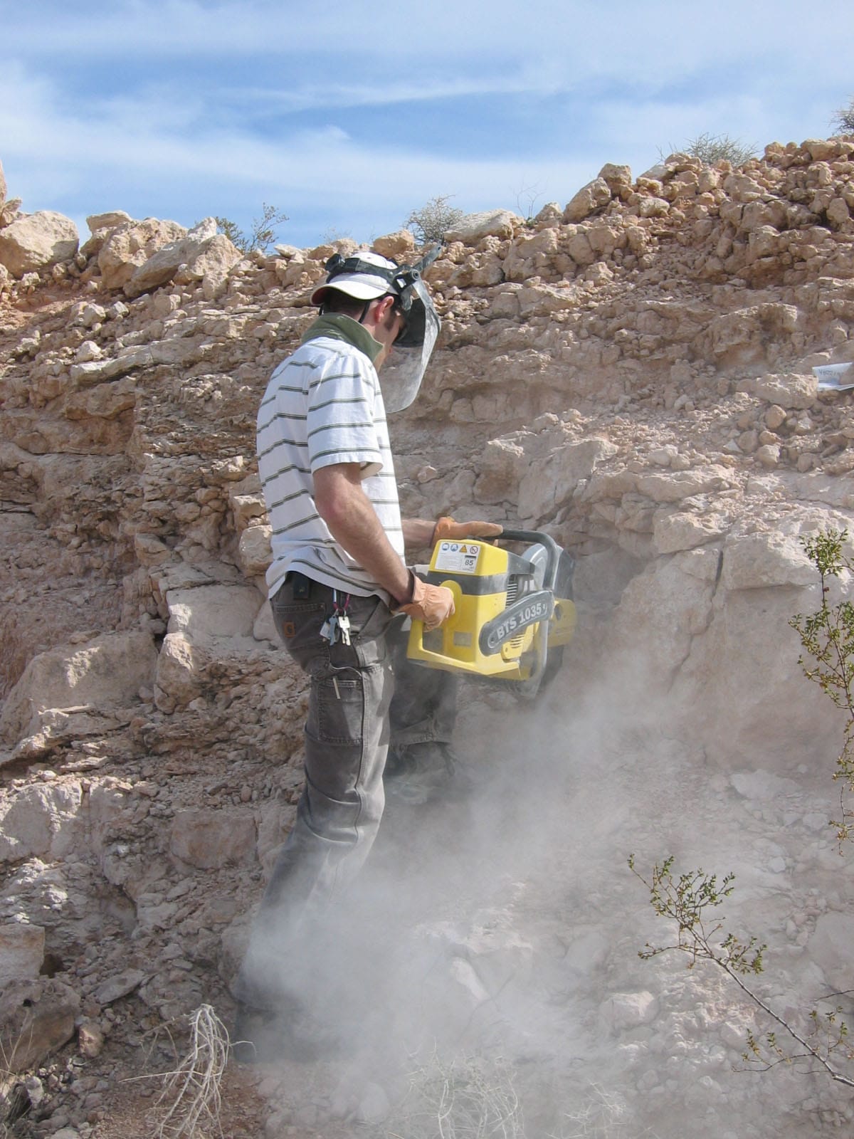
SAFETY ISSUES Vehicle travel along the L.A.-Las Vegas I-15 corridor poses the single greatest risk in this project. All effort will be made to avoid northbound travel on Fridays, and southbound travel late on Sundays, when traffic is at its worst. Summer temperatures in the Mojave Desert are extreme, often exceeding 110°F. Even brief visits to remote field sites short distances from well-maintained air-conditioned vehicles in June/July can prove draining, especially when sampling or describing profiles. By starting promptly at sunrise and ending by 2pm, and with a short number of successive days in heat, we can safely achieve the objectives of profile description, stratigraphic description, photography, and sampling. All sample sites in this project are on Bureau of Land Management parcels in existing road or wash cuts, and a permit request for June 2018 sampling has already been submitted and is pending now. Sampling requires a gas-powered concrete-cutting chain saw (e.g., a “quickie” saw commonly used in construction). With proper use, maintenance, and all due safety precautions (e.g., personal protective gear including hard hat, face shield, and safety glasses) the likelihood of accidents is low, however, some risk is inherent whenever using power tools. Students will train on the saw in Claremont prior to fieldwork; they must be comfortable lifting 50 pounds to do so. Rattlesnakes are a risk, but sampling noise usually scares wildlife away. In Claremont, all students are required to attend chemical safety and fire extinguisher training sessions (free) before starting lab work in the W.M. Keck Science Department.
PROFESSIONAL DEVELOPMENT
Students will be expected to co-author at least one collaborative poster on mineralogy, micromorphology, and soil-geomorphic evolution of the Mormon Mesa petrocalcic soil for the Geological Society of America meetings in Indianapolis, IN, November 4-7, 2018. GSA 2018 is a perfect early target date for students to summarize their individual and group research efforts, and this project will support student travel, registration, and lodging for attendance and presentation at the GSA meetings. Excitingly, the relatively young GSA Soils and Soil Processes Working Group (new title forthcoming) is becoming permanently established and provides a nice network for student learning. All students are required to complete a 4-6 page paper (short contribution) that will be published in the Proceedings of the Keck Geology Consortium 2019 Volume (see examples from previous years). The first draft of this paper will be reviewed by your research advisor at your home institution sometime in late February, 2019, with the revised version sent to the project directors by March 1. Final versions of your paper and figures will be submitted to the Keck Office in Mid-March.
References
Alonso-Zarza, A.M. and Silva, P.G., 2002. Quaternary laminar calcretes with bee nests: evidences of small-scale climatic fluctuations, Eastern Canary Islands. Palaeogeography, Palaeoclimatology, Palaeoecology, 178: 119-135.
Bachman, G.O., and M.N. Machette. 1977. Calcic soils and calcretes in the southwestern United States. U.S. Geological Survey Open File Report 77-794. U.S. Gov. Print. Office, Washington, DC.
Blount, C.W., 1977. Barite solubilities and thermodynamic quantities up to 300°C and 1400 bars. American Mineralogist, 62: 942-957. Brady, N.C. and Weil, R.R., 2008. The nature and properties of soils, fourteenth edition (revised). Pearson Prentice Hall, Upper Saddle River.
Brock, A.L. and Buck, B.J., 2005. A new formation process for calcic pendants from Pahranagat Valley, Nevada, USA, and implication for dating Quaternary landforms. Quaternary Research, 63(3): 359-367.
Brock, A.L. and Buck, B.J., 2009. Polygenetic development of the Mormon Mesa, NV petrocalcic horizons: Geomorphic and paleoenvironmental interpretations. Catena, 77: 65-75.
Brock-Hon, A.L., Robins, C.R. and Buck, B.J., 2012. Micromorphological investigation of pedogenic barite in Mormon Mesa petrocalcic horizons, Nevada USA: Implication for genesis. Geoderma, 179-180: 1-8.
Chadwick, O.A. and Chorover, J., 2001. The chemistry of pedogenic thresholds. Geoderma, 100: 321-353.
Deutz, P., Montañez, I.P., Monger, H.C. and Morrison, J., 2001. Morphology and isotope heterogeneity of Late Quaternary pedogenic carbonates: Implications for paleosol carbonates as paleoenvironmental proxies. Palaeogeography, Palaeoclimatology, Palaeoecology, 166(3-4): 293-317.
Dixon, J.B., and S.B. Weed, editors. 1989. Minerals in soil environments, 2nd edition. SSSA Book Series 1. Soil Science Society of America, Madison, WI.
Duniway, M.C., Herrick, J.E. and Monger, H.C., 2007. The high water-holding capacity of petrocalcic horizons. Soil Science Society of America Journal, 71(3): 812-819.
Faulds, J.E., L.A. Gonzalez, M.E. Perkins, P.K. House, P.A. Pearthree, S.B. Castor, and P.J. Patchett. 2002. Late Miocene-Early Pliocene transition from lacustrine to fluvial deposition: inception of the lower Colorado River in southern Nevada and northwest Arizona. Geol. Soc. Am. Abst. Prog. 34(4):60.
Gardner, L.R., 1972. Origin of the Mormon Mesa Caliche, Clark County, Nevada. Geological Society of America Bulletin, 83: 143-156.
Gile, L.H., Hawley, J.W. and Grossman, R.B., 1981. Soils and geomorphology in the Basin and Range area of Southern New Mexico – Guidebook to the Desert Project. New Mexico Bureau of Mines & Mineral Resources, Memoir 39. University of New Mexico, Socorro, 222 pp.
Graham, R.C., Hirmas, D.R., Wood, Y.A. and Amrhein, C., 2008. Large near-surface nitrate pools in soils capped by desert pavement in the Mojave Desert, California. Geology, 36(3): 259-262.
Hanor, J.S., 2000. Barite-celestine geochemistry and environments of formation. In: C.N. Alpers, J.L. Jambor and D.K. Nordstrom (Editors), Sulfate minerals: crystallography, geochemistry, and environmental significance. Reviews in Mineralogy and Geochemistry. The Mineralogical Society of America, Washington, pp. 192-275.
House, P.K., Pearthree, P.A., Howard, K.A., Bel, J.W., Perkins, M.E., Brock, A.L., 2005. Birth of the lower Colorado River – Stratigraphic and geomorphic evidence for its inception near the conjunction of Nevada, Arizona, and California, in: Pederson, J., Dehler, C.M., eds., Interior Western United States: Boulder Colorado, Geological Society of America Field Guide 6. Geological Society of America, Boulder.
Jennings, D.S. and Driese, S.G., 2014. Understanding barite and gypsum precipitation in upland acid-sulfate soils: An example from a Lufkin Series toposequence, south-central Texas, USA. Sedimentary Geology, 299: 106-118.
Kabata-Pendias, A., 2011. Trace elements in soils and plants, fourth edition. CRC Press, Boca Raton, FL, 505 pages pp. Kowallis, B.J., and B.H. Everett. 1986. Sedimentary environments of the Muddy Creek Formation near Mesquite, Nevada. Sed. Assoc. Pub. 15:69-75.
Kraimer, R.A. and Monger, H.C., 2009. Carbon isotopic subsets of soil carbonate – A particle size comparison of limestone and igneous parent materials. Geoderma, 150: 1-9.
Lynn, W.C., Tu, H.Y. and Franzmeier, D.P., 1971. Authigenic barite in soils. Soil Science Society of America Proceedings, 35: 160-161.
Machette, M.N., 1985. Calcic soils of the southwestern United States. In: D.L. Weide (Editor), Soils and Quaternary Geology of the southwestern United States, pp. 1-21.
Quade, J., Eiler, J., Daëron, M. and Achyuthan, H., 2013. The clumped isotope geothermometer in soil and paleosol carbonate. Geochimica et Cosmochimica Acta, 105(Supplement C): 92-107.
Reeves, C.C., Jr., 1976. Caliche: origin, classification, morphology and uses. Estacado Books, Lubbock, 233 pp. Retallack, G.J., 2001. Soils of the past: An introduction to paleopedology. Blackwell Science, Malden, MA, 404 pp.
Robins, C.R., Brock-Hon, A.L. and Buck, B.J., 2012. Conceptual mineral genesis models for calcic pendants and petrocalcic horizons, Nevada. Soil Science Society of America Journal, 76(5).
Robins, C.R., Buck, B.J., Spell, T.L., Soukup, D.A. and Steinberg, S.M., 2014. Testing the applicability of vacuum-encapsulated 40Ar/39Ar geochronology to pedogenic palygorskite and sepiolite. Quaternary Geochronology, 20: 8-22.
Robins, C.R., Deurlington, A., Buck, B.J. and Brock-Hon, A.L., 2015. Micromorphology and formation of pedogenic ooids in calcic soils and petrocalcic horizons. Geoderma, 251-252: 10-23.
Schmidt, D.L., W.R. Page, and J.B. Workman. 1996. Preliminary geologic map of the Moapa West Quadrangle, Clark County, Nevada. U.S. Geological Survey Open-File Report 96-521.
Soil Survey Staff. 2006. Official Soil Series Descriptions. USDA-NRCS http://soils.usda.gov/technical/classification/ osd/index.html (accessed 1 April 2006).
Stoops, G.J. and Zavaleta, A., 1978. Micromorphological evidence of barite neoformation in soils. Geoderma, 20: 63-70.
Sullivan, L.A. and Koppi, A.J., 1993. Barite pseudomorphs after lenticular gypsum in a buried soil from Central Australia. Australian Journal of Soil Research, 31: 393-396.
United States Geological Survey (USGS), 2005. Seamless Data Distribution Digital Elevation Models. U.S. Department of the Interior http://seamless.usgs.gov/ (accessed 1 Aug. 2005).
Watts, N.L., 1980. Quaternary pedogenic calcretes from the Kalahari (southern Africa): mineralogy, genesis and diagenesis. Sedimentology, 27: 661-686.
Williams, V.S., Bohannon, R.G. and Hoover, D.L., 1997. Geologic map of the Riverside Quadrangle, Clark County, Nevada, Geologic Quadrangle Map GQ-1770.