Students and faculty of the Keck Colorado Project will make field measurements and collect samples to help characterize the: (1) importance of fire in the critical zone; (2) the geomorphic significance of catastrophic floods in channel and floodplain evolution; and (3) the variable effects of the September 2013 floods from the upper to lower Fourmile basin. Broader research questions include:
• How does fire influence the long-term evolution of hillslopes and channels in the area?
• How does the architecture of critical zone development control the hydrologic response of the Fourmile catchment to precipitation at higher and lower elevations?
• How does the legacy of land-use, including placer and hard-rock mining, impact stream sediment transport and geochemistry in Fourmile Canyon?
- What do the short-lived isotopes 7Be, 137Cs and 210Pb tell us about erosion processes and rates on hillslopes and in the channels of the study area?

Erosion of mine tailings in 2011 after Fourmile fire (from Murphy, 2011) and battered pickup in September 2013 flood debris, Fourmile Canyon, Colorado

What: Students and faculty of the Keck Colorado Project will make field measurements and collect samples to help characterize the: (1) importance of fire in the critical zone; (2) the geomorphic significance of catastrophic floods in channel and floodplain evolution; and (3) the variable effects of the September 2013 floods from the upper to lower Fourmile basin. Broader research questions include:
• How does fire influence the long-term evolution of hillslopes and channels in the area?
• How does the architecture of critical zone development control the hydrologic response of the Fourmile catchment to precipitation at higher and lower elevations?
• How does the legacy of land-use, including placer and hard-rock mining, impact stream sediment transport and geochemistry in Fourmile Canyon?
- What do the short-lived isotopes 7Be, 137Cs and 210Pb tell us about erosion processes and rates on hillslopes and in the channels of the study area?
When: 2 July to 30 July 2014
Where: Front Range west of Boulder, Colorado
Who: Six undergraduate students and three project leaders: David Dethier (Williams College), Will Ouimet (University of Connecticut) and James Kaste (College of William and Mary)
Project Overview
The September 2013 canyon floods along the Colorado Front Range highlight how the evolution of landscapes can be regulated by episodic sediment mobilization and deposition during extreme rainfall events. Combined with the effects of wildfires, which occur regularly in this region, this event presents a rare opportunity to characterize landscape response to the combined effects of wildfire and extreme flooding along channel reaches that have been affected by both. Fourmile Canyon, the focus of the Keck Colorado 14 project, experienced a large, intense wildfire in September 2010, post-fire flooding in summer 2011 and 2012, and catastrophic flooding and erosion in September 2013. Fourmile Creek drains alpine, montane, and lower-elevation catchments, each of which responded differently to the September rainstorm and likely to previous extreme events.
The Keck Colorado 14 project will work in cooperation with the US Geological Survey (Boulder, Colorado) and with the Boulder Creek Critical Zone Observatory (CZO). The “observatory” consists of 3 small, instrumented sites in the Boulder Creek basin (Fig. 1) adjacent to the Fourmile catchment: (1) Green Lakes Valley—a steep, glaciated alpine area in the Boulder watershed where “fresh” materials are exposed at the surface; (2) Gordon Gulch—a forested, mid-elevation catchment developed in weathered materials, and (3) Betasso—a steep, lower-elevation basin where surficial deposits are of variable thickness. The CZO catchments are heavily instrumented and the flux of water and solutes is monitored at lysimeters and at gaging stations; surficial geology has been characterized by previous Keck projects using mapping, soil pits and geophysical techniques. Fourmile Creek has been closely monitored since the 2010 fire, and several slope sites have monitored erosion rates, but much of this monitoring has been suspended or was destroyed by the floods. Our proposed work will help our understanding of the role of extreme events from a long-term geomorphic and hazards perspective.
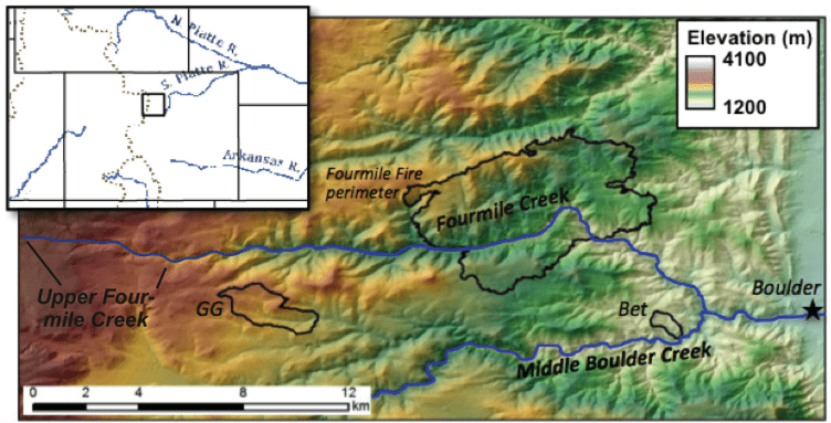
Fig. 1. Shaded relief and slope map of Fourmile Creek area. Steepest slopes shaded red; shallowest slopes are blue. Study catchments include Fourmile Creek, the Green Lakes Valley, Gordon Gulch (GG) and Betasso (Bet).
Setting
Fourmile Creek is a tributary of the middle Boulder Creek catchment (Fig. 1), which extends from the glaciated alpine zone of the Indian Peaks Wilderness Area east to the semi-arid western edge of the Great Plains. Deep, U-shaped valleys in the glaciated areas become shallower eastward through a zone of low relief and relatively low slopes, deepen into steep bedrock canyons as they pass knickzones, and flatten to lower channel slopes near the piedmont margin. Small glaciers and late-persisting snowfields dot the alpine zone, which exposes bedrock and relatively thin deposits related to the latest Pleistocene Pinedale glaciation. Thick (characteristically 3 to 8 m) zones of grus, saprolite and oxidized bedrock are common in the thinly forested zone of low relief. The most intensely burned area in 2010 coincides with an 1860-1945 gold-mining district (Fig. 2) and was swept by a catastrophic flood in 1894, resulting in a long history of channel disruption, modification and recovery, and sediment that contains a legacy of this history.
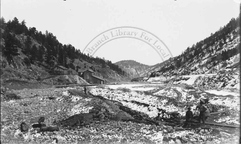
Fig 2. Placer mining along Fourmile Canyon near the Wood Mtn. mine (c. 1910) sample sit
Potential student projects
Students and project faculty will collect data and solid or liquid samples at field sites. We will work on initial sample treatment at the Mountain Research Station (MSR) or at the US Geological Survey in Boulder. We expect that participants will return to their home schools with field maps and notes, initial results of field measurements and samples ready for preparation and additional analysis. Data from geochemical analyses (as necessary) will probably return sometime in the fall semester. Analysis and interpretation of field and laboratory results and preparation of graphics at the home institution will be supervised by the student’s advisor and aided by the Project Directors. Some potential student projects include:
- Mapping the distribution of erosion and channel and overbank deposition in areas swept by catastrophic flooding in September 2013.
- Home institution activities might include: sediment volume calculations; stream power calculations and interpretation; GIS analysis incorporating Lidar and field
mapping/measurements; grain size analysis. - Measuring variations in soil morphology, chemistry, sediment generation and transport processes along slope transects on burned and unburned slopes within the 2010 Fourmile burn area and in adjacent areas that burned 30 to 50 years ago.
- Home institution activities might include: air-photo analysis; GIS analysis incorporating Lidar and field mapping/measurements; drying and sieving samples for analysis (geochemistry; 137Cs and 210Pb); grain size analysis
- Characterizing the hydrogeochemistry of shallow groundwater and meltwater near late-lying snowfields in upper Fourmile Creek and adjacent areas.
- Home institution activities might include: prepping and running stream samples for geochemistry; data analysis; GIS analysis incorporating Lidar with field measurements of discharge and temperature
- Assessing the legacy of land-use, including placer and hard-rock mining, on stream sediment and geochemistry in the Fourmile basin
- Home institution activities might include: finding and analyzing additional historic documents and images of mining and land-use history of the canyon; GIS analysis integrating historic data with the Lidar base; possibly preparation of samples for geochemical analysis
- Comparing the coupling of hillslope erosional processes, channel morphology and sediment transport in lower (burned) to upper (unburned) Fourmile Creek
- Home institution activities might include: GIS analysis integrating field mapping and the Lidar base; preparing samples for analysis (7Be, 137Cs and 210Pb).
- Characterizing the effects of the catastrophic 2013 flood on evolution of the Fourmile ‘knickzone’ and its role in determining hillslope and channel processes throughout the study area.
- Home institution activities might include: river profile analysis; thin-section analysis; GIS analysis integrating Lidar and field mapping/measurements
- Comparing the Holocene record of flooding, landform development and sedimentation within Fourmile Canyon to that of nearby areas such as Lefthand Canyon.
- Home institution activities might include: landform mapping and river profile analysis using GIS and the Lidar base; preparation of samples for 14C analysis.
- Home institution activities might include: sediment volume calculations; stream power calculations and interpretation; GIS analysis incorporating Lidar and field
Logistics and working conditions
Students will fly into Denver, Colorado on 2 July and drive up to the University of Colorado’s Mountain Research Station (http://www.colorado.edu/mrs/), where project participants will live and eat at 9500 feet at the edge of the alpine part of the Boulder Creek catchment. Housing consists of rustic cabins; meals and lunch ingredients are served in a central lodge. The Station has laboratory, lecture, library and limited computer facilities, a local wireless network and provides regular weekday transportation to Niwot Ridge. Niwot Ridge (Fig. 3), adjacent to the Mountain Research Station, is the source of Fourmile Creek, the site of long-term ecological research (LTER) and the location for ecology and evolutionary biology research and for extensive studies about periglacial
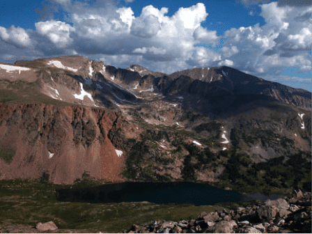
Figure 3. View north from Niwot Ridge near the Mountain Research Station.
processes and landforms, snowmelt processes, and biogeochemical cycling (http://www.colorado.edu/mrs/research-natural-history). Keck Project participants will be housed adjacent to and will eat and recreate with students and graduate students doing research on Niwot Ridge and in nearby study catchments of the Boulder Creek Critical Zone Observatory. In past years these interactions have led to students helping each other on project “push” days and to some extraordinary cross-disciplinary education.
We will spend part of the first week learning about local geology and research from investigators on the NSF grant, using a lecture and field trip format, and visiting each of the field locations and nearby Rocky Mountain National Park. Students will use this regional and site-specific background and consultation with project faculty to decide on their individual research topics (see examples below); projects will depend, in part, on the logistics of the individual sites. We’ll working at elevations ranging from 6,000 to 12,500 feet and in environments from the hot semidesert to late-lying snowfields! Most of the projects involve some hiking in steep forested or burned terrain; upper Fourmile projects will involve longer traverses. Local weather is unpredictable and highly variable, but usually includes thunderstorms on some days and in some places! We expect that students will work as a group at times and in pairs at other times at local sites. Communication on-site will be by GPS/radio receivers. Project participants will return home from Denver on 30 July.
Necessary and preferred student background
Important for this interdisciplinary project is a strong interest in surface and near-surface processes and in interdisciplinary science, a record of hard work and the ability to follow through. We prefer gregarious, “can-do” students with a background in geology or physical geography and coursework in:
Earth materials and/or geochemistry
Geomorphology/Quaternary geology or hydrology
GIS or field mapping (valuable)
Sedimentology and/or soils (valuable)
Structural geology or a strong background in supporting science (useful)
